

Activity in the Atlantic basin has exploded this week.
Tropical Storm Cristobal formed east of Bermuda Aug. 12, and the National Hurricane Center is tracking two invests expected to strengthen into tropical depressions over the coming days. Cristobal weakened into a tropical depression by 5 a.m. Aug. 13.

➤ Track all active storms
The closest one to Florida, Invest 92L, could become a tropical depression within the next day or two as it approaches the Caribbean, according to the National Hurricane Center.
Shop Amazon for hurricane prep
Behind it is another tropical wave, designated as Invest 94L late Aug. 12.
As always, Florida residents were advised to keep an eye on the tropics and to always be prepared.
➤ Weather alerts via text: Sign up to get updates about current storms and weather events by location
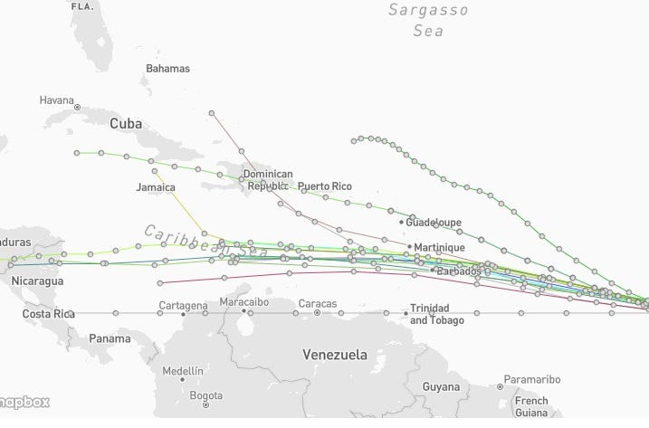
Invest 92L spaghetti models. See expected path
Special note about spaghetti models: Spaghetti model illustrations include an array of forecast tools and models, and not all are created equal. The Hurricane Center uses only the top four or five highest performing models to help make its forecasts.
Invest 92L likely to become tropical depression soon
At 2 a.m. Aug. 13, the National Hurricane Center said Invest 92L is likely to become a tropical depression over the next couple of days.
➤ Get the latest information on Invest 92L
➤ Track Invest 92L
What impact could Invest 92L have on Florida?
“The tropical wave east of the Caribbean is currently in a zone that is generally favorable for development this week,” AccuWeather Lead Hurricane Expert Alex DaSilva said. “The tropical wave has a high chance of development.
“The most likely time for development of this tropical wave is from Thursday to Friday,” DaSilva said.
The storm would have to stay organized and strong enough to survive extensive wind shear over the Caribbean. But if it gets too strong before reaching U.S mainland waters, it will turn north and track well east of the East Coast, according to AccuWeather.
“The area we are most concerned about impacts at this point is the Lesser Antilles and Puerto Rico.”
“The stronger the wave becomes, the more likely it is to move north and away from the Lesser Antilles. If this happens, the storm will likely move north into the open Atlantic and not impact the U.S. (or Florida),” said Nick Arman, AccuWeather forecasting operations meteorologist, via email Aug. 12.
“If the wave stays weaker, there is the chance it could move a little closer to the Southeast coast, however it would have to get through a wall of wind shear which would likely substantially disrupt the storm. If this would approach the U.S. it wouldn’t be until mid to late next week, so we have plenty of time to watch it.”
What will be next named storms in Atlantic basin?
Dolly and Edouard are the next two names for the Atlantic basin, which covers the Atlantic, Gulf of America and Caribbean.
How strong are winds for a tropical depression?
A tropical depression has maximum sustained surface winds — based on a one-minute average — of 38 mph or less, according to the National Weather Service.
How strong are winds for a tropical storm?
A tropical storm has maximum sustained surface winds ranging from 39-73 mph.
Track all active Atlantic, Pacific storms
This auto-updated graphic shows a map of all active storms in the Atlantic basin.
Can’t see the graphic? Open in a new browser.
See NWS weather radar for Florida, southeastern US
Latest weather watches and warnings issued in Florida
Excessive rainfall forecast across Florida
Stay informed. Get weather alerts via text
What’s next?
We will update our tropical weather coverage daily.
Download your local site’s app to ensure you’re always connected to the news. And look for our special subscription offers here.
Cheryl McCloud is a journalist for the USA TODAY Network-Florida’s service journalism Connect team. You can get all of Florida’s best content directly in your inbox each weekday day by signing up for the free newsletter, Florida TODAY, at https://palmbeachpost.com/newsletters.
This article originally appeared on Palm Beach Post: See latest spaghetti models for Invest 92L. Is it coming toward Florida?
Reporting by Cheryl McCloud, USA TODAY NETWORK – Florida / Palm Beach Post
USA TODAY Network via Reuters Connect
By Cheryl McCloud, USA TODAY NETWORK – Florida | USA TODAY Network
