Spirit Halloween sent the Pensacola area its first signals that fall is quickly approaching as the first store opened last week, but it may be a while yet before we see cooler weather — and fall may not feel very much like fall.
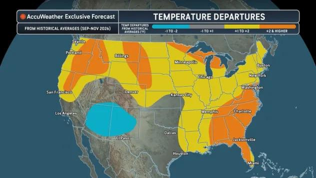
Exceptionally warm waters surrounding Florida will maintain summer-like temperatures and humidity throughout the Panhandle, and much of the state, through November, according to AccuWeather.

Fall temperatures in the Pensacola area are expected to be about two degrees warmer than the historical average. But high temperatures won’t be the only problem.
El Niño will shift the subtropical jet stream south. An intense El Niño, like the one we’re expecting to see, will cause the jet stream to move farther south, which will bring in more rain and elevated chances of severe storms.
Here’s what Pensacola residents should know about the latest fall weather forecast.
When does fall start?
Meteorological fall starts on Sept. 1, while astronomical autumn happens on the equinox, which starts on 7:05 CT on Sept. 22.
Pensacola area will see some of the warmest fall temperatures
The majority of Florida is among a swath of the southeastern United States that AccuWeather predicts will feel the warmest this fall.
AccuWeather forecasters estimate that fall temperatures in the Florida Panhandle and most of the state could see temperatures at least two degrees higher than average through November.
While El Niño is helping to suppress tropical cyclone organization in the Atlantic basin, sea surface temperatures are still warm, which has a big impact on temperatures along the Gulf Coast. Warmth and humidity come in from the Gulf, which elevates temperatures and dew points.
AccuWeather also notes a possible lack of cooler air pouring in from the north.
“It may not be until October before the first intrusions of chilly air arrive in the north-central Plains, Great Lakes and Northeast, but these cold outbreaks are not expected to be long-lasting,” AccuWeather wrote in its latest forecast.
A lack of cooler air penetrating into the northern parts of the country leaves little hope of that air reaching Florida.
When will Pensacola first see cooler weather?
Temperatures in Pensacola tend to drop quite a bit once fall starts to settle in around October. The historical average temperature in Pensacola between 2000 and 2025 is around 71 degrees, according to data from the National Weather Service. So days would still feel quite a bit cooler compared to the 83-degree average we see during July and August.
The highest average temperature seen during this period is 74.8 degrees, which occurred in 2018. If temperatures do hit two degrees higher than average, it would be around the ninth warmest fall over the past 26 years, according to the NWS.
Pensacola is still likely to see its first sub-70-degree low temperature in October, when lows tend to average around 61 degrees. However, unless a streak of cool air does shoot southward, November is likely the first time Pensacola will see an average temperature drop into the 60s.
Danger could still lurk in the tropics
Hurricane season doesn’t end until Nov. 30, and it really starts to hit its stride in September. While Colorado State University has revised and drastically reduced the number of named storms expected this season, it only takes one bad storm to cause major damage.
“In the Atlantic basin, El Niño may hold back the number of named storms in 2026, but there can still be several impacts on the United States,” Pastelok said.
So far, the only two named storms to spin up this season have both made landfall along the Gulf Coast, and the National Hurricane Center is keeping an eye on two disturbances making their way across the Atlantic.
Other severe weather, flooding risks expected to shift south
AccuWeather forecasters warn that the El Niño-driven weather pattern and warm water from the Gulf will help fuel thunderstorms and heighten flood risk without the help of a tropical cyclone.
“The severe weather focus should gradually shift from the northern part of the Plains and Midwest toward the southern part of the Plains, Gulf Coast and the Tennessee Valley through the fall,” Pastelok said, adding that this shift is typical during the course of the fall.
This article originally appeared on Pensacola News Journal: Fall is forecast to arrive late in Pensacola. Here’s why
Reporting by Brandon Girod, Pensacola News Journal / Pensacola News Journal
USA TODAY Network via Reuters Connect
By Brandon Girod, Pensacola News Journal | USA TODAY Network