Shasta County motorists driving on Aug. 16, should take detours and plan for traffic delays and congestion in the Redding area during the 2026 IRONMAN triathlon race.
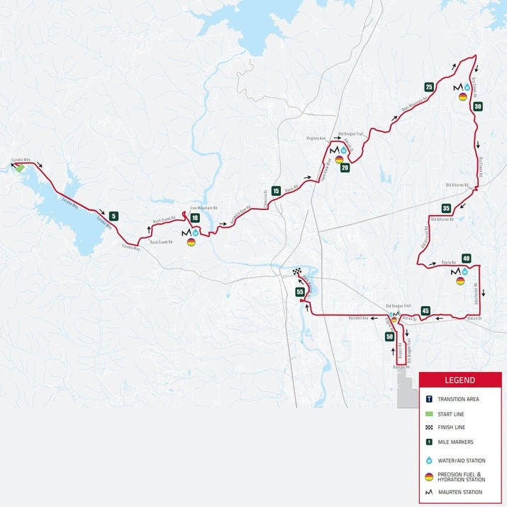
Law enforcement will close roads as participating athletes swim, bike and run through Whiskeytown National Recreation Area, the Shasta-Trinity National Forest and greater Redding areas.

Road closures and detours include stretches through or near residential areas, according to race planners. Drivers won’t be able to use closed streets for up to 4.5 hours on race day, so roads serving as detours could see higher traffic than most Sundays, said city of Redding Communications Manager Katie Hunter.
Here are detours drivers can take, which roads close and when, and a list of other streets that could face heavy traffic on Aug. 16, according to the city of Redding and race planners.
Note to readers: If you appreciate the work we do here at the Redding Record Searchlight, please consider subscribing yourself or giving the gift of a subscription to someone you know.
Where you can go: These roads serve as detours during the 2026 Redding IRONMAN
The following roads serve as detours for closed areas during the 2026 Redding Iron man on Aug. 16, according to race planners. “There will be traffic control signage in place alerting drivers to these routes,” Hunter said.
Note traffic could be heavier than usual on these streets as drivers use them to navigate around closures.
North Redding detours
East Redding/Highway 299 detours
Northeast/east Redding detours
Highway 44/central Redding detours
Times each Shasta County road closes during 2026 Redding IRONMAN
Here’s a list of roads race planners said are completely or partially closed, and the hours they’re off limits to traffic on race day.
Northwest Redding area
Oasis Road area
Northeast/east Redding
East/southeast Redding
Central Redding/downtown
When Hwy 299 and parts of Whiskeytown close
Whiskeytown National Recreation Area will stay open, the Redding Police Department announced, but Highway 299 and Oak Bottom will be slow going for motorists on Sunday morning.
Roads and intersections with heavy traffic during the Redding IRONMAN
Motorists on these roads may see heavier than usual Sunday morning traffic, race planners said.
Highway 299 and west/northwest Redding area
Old Oregon Trail area
North Redding and near Bella Vista
Northeast/east Redding
Hartnell Avenue intersections
Jessica Skropanic is a features reporter for the Record Searchlight/USA Today Network. She covers science, arts, social issues and news stories. Follow her on Twitter @RS_JSkropanic and on Facebook. Join Jessica on Record Searchlight Facebook groups Get Out! Nor Cal, Today in Shasta County and Shaping Redding’s Future. To support and sustain this work, please subscribe today. Thank you.
This article originally appeared on Redding Record Searchlight: Redding detours, roads closed and traffic warnings during IRONMAN race
Reporting by Jessica Skropanic, Redding Record Searchlight / Redding Record Searchlight
USA TODAY Network via Reuters Connect
By Jessica Skropanic, Redding Record Searchlight | USA TODAY Network