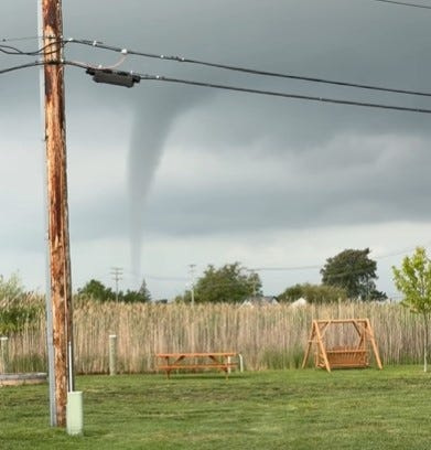
A video posted on Facebook appears to show a funnel cloud near Harsens Island in Lake St. Clair on Aug. 22.
The video, time stamped 9:35 a.m., was posted to the Michigan Storm Chasers page on Facebook by an anonymous user. Storm Chasers called it a “potential waterspout.” In a later post, the group called it a waterspout.

It’s unclear if the waterspout moved ashore and did damage. The National Weather Service was not available immediately for comment.
Tornadic waterspouts are “simply tornadoes that form over water, or move from land to water,” according to https://www.weather.gov/mfl/waterspouts.
“They have the same characteristics as a land tornado. They are associated with severe thunderstorms, and are often accompanied by high winds and seas, large hail, and frequent dangerous lightning,” the website says.
The National Weather Service said in a Severe Weather Outlook early Saturday morning that showers and thunderstorms were expected to develop Saturday morning and afternoon across all of Southeast Michigan. It said that damaging wind gusts up to 60 miles per hour, small hail and localized flooding would be possible.
Attempts to reach the Harsens Island Fire Department and Clay Township Police Department for comment were unsuccessful.
asnabes@detroitnews.com
This article originally appeared on The Detroit News: Video appears to show funnel cloud in Lake St. Clair
Reporting by Anne Snabes, The Detroit News / The Detroit News
USA TODAY Network via Reuters Connect
By Anne Snabes, The Detroit News | USA TODAY Network