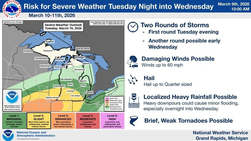
Parts of mid-Michigan could see severe thunderstorms Tuesday, March 10, into Wednesday, March 11, the National Weather Service said, as well as a mix of wintry precipitation.
“Several rounds of strong to severe storms will be possible Tuesday evening into early Wednesday,” the NWS Grand Rapids office said on X on March 9. “(The) Area of most concern is along and south of the Interstate 96 corridor.”

The weather service said to expect damaging winds and large hail, but tornadoes are possible. Heavy rainfall could cause minor flooding, the agency added.
“Enhanced low-level shear in vicinity of the boundary may also lead to a few tornadoes, some of which could be strong,” the forecast said.
The NWS said a “complex upper-level pattern” will bring a more widespread risk for both severe weather and flash flooding across much of the Midwest.
“Storms are expected to focus both along a very slow moving cold front from the Great Lakes southwest through the Missouri Valley and into the central Plains and ahead of a Pacific front moving eastward through the southern Plains, with plentiful deep-layer shear and moisture/instability to support intense thunderstorms,” the NWS Weather Prediction Center said.
In addition to the severe weather threat, in the colder air to the north of the boundary, a couple rounds of wintry precipitation are forecast from the northern Plains to the Upper Great Lakes Monday and then on Tuesday into Wednesday, the weather service said.
“The greatest chance for some light to moderate accumulating snowfall and ice accretions will be across the Upper Great Lakes with the second round beginning Tuesday,” the NWS said.
For the Lansing area, highs on Monday, March 9, could reach 67 with clouds increasing overnight.
Tuesday, the chance for rain showers increases throughout the day with thunderstorms possible after 8 p.m. Up to an inch of rain is possible.
Wednesday, rain will continue through much of the day with highs only in the 40s.
Rain and snow showers are likely Wednesday night, turning to all snow by early Thursday before clearing.
Rain and snow are possible again Thursday night and through Sunday, the weather service said.
See Lansing-area Doppler radar
Current weather warnings and advisories
This article originally appeared on Lansing State Journal: Severe weather possible Tuesday. What the NWS says about storms
Reporting by Dan Basso, Lansing State Journal / Lansing State Journal
USA TODAY Network via Reuters Connect