The Rouge River has a rough history.
For most, the river running southwest through Wayne County communities to the Detroit River conjures images of heavy industry and pollution − its oil-choked waters famously caught fire in 1969. It was identified as an “Area of Concern” by the U.S. and Canadian governments, an area needing special attention for its pollution.

Many years of effort have resulted in higher water quality, and Wayne County, the nonprofit Friends of the Rouge and other partners have worked for years to improve greenway trails along the Rouge and to provide access to the river itself for paddling.
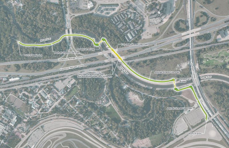
A long-in-the-works second phase to the Rouge Gateway Greenway project is slated to begin construction this year, extending a riverside trail system an additional 1.9 miles, from just west of Evergreen Road and north of Michigan Avenue in Dearborn at the confluence of the Lower and Main Branch of the Rouge River, extending downstream to west of Southfield Freeway at Village Road near the Henry Ford museum.
“It’s kind of a forgotten natural asset,” said Herman Jenkins, trails manager for Friends of the Rouge.
“Rivers, lakes, streams can serve as natural connective tissue for communities, and that’s really what the Rouge is and can be. But for many years, this river was hidden behind these walls of industry, particularly in communities like south Dearborn, Detroit, River Rouge.”
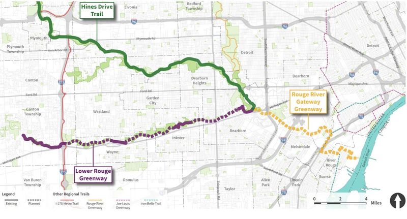
Planning for the Rouge Gateway Greenway began in 2001, with local, state and federal agencies thinking about an overarching vision for restoring wetlands, river shoreline and fish and wildlife habitats while enhancing public access. Phase one of the greenway, from Hines Drive north of Ford Road and extending to Dearborn’s west retail area on Michigan Avenue, was completed in 2005. It features a 10-foot-wide asphalt recreational path with a green buffer of natural plants, with work to remove invasive species and provide for river views, Jenkins said.
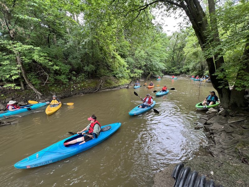
Friends of the Rouge is working with 10 nearby communities and Wayne County to develop a water trail that will complement the developing network of connected greenways along the Lower Rouge, from Canton to the Detroit River. The work includes developing and improving river access points for paddlers, signage and debris removal for a better experience.
“Those upstream communities − Canton, Dearborn, Dearborn Heights, Wayne, Inkster − it is truly a picturesque experience,” Jenkins said. “It’s a dense tree canopy. The wildlife is unbelievable − we’ve seen great blue heron, green heron, deer, bald eagles. I actually saw an owl on a paddle trip, which was fascinating. I’ve never seen a bird with a head that big in my life. Deer crossing right in front of you, yards away from your canoe as you are paddling downstream. It really is a cool experience. The urban landscape completely disappears.”
The U.S. Army Corps of Engineers lined the Lower Rouge River with concrete in the 1960s and ’70s, an effort to move stormwater rapidly out of the watershed and prevent sewage from backing up in upstream residential basements. The Army Corps and U.S. Environmental Protection Agency are now working on designs for a habitat restoration project for the areas of land along the concrete lining, along with “resting areas” for fish in the waters of that segment of the river. An oxbow, a crescent or U-shaped river feature with stiller waters that creates important habitat, was restored near The Henry Ford and completed in 2019.
Even the more industrialized segments of the Rouge River make for an interesting paddling experience, Jenkins said.
“You paddle into the industrial channel of the Rouge, and it’s like going on a tour of the history of Detroit’s manufacturing,” he said. “The original Ford Rouge manufacturing plant is there; you have active industry; all of these one-of-a-kind drawbridges, Zug Island and its history, the history of the channelization of the Rouge. And now when you paddle around the Zug Island Channel and pop out into the Detroit River, the new Gordie Howe International Bridge is sitting like right on top of your head.”
The years-long gap between the completion of Phase 1 of the Rouge Gateway Greenway and the start of construction on Phase 2 involved a complicated permitting process, said Elizabeth Iszler, chief of planning and design for Wayne County Parks.
“Michigan Avenue, that block, is very hard,” she said. “There’s all that spaghetti of roads in the way. This phase we are working on now was the hardest. … A lot of this project has been a couple of years just getting permits, because you are going under a rail line, you’re going under an MDOT bridge.”
Friends of the Rouge secured $6.9 million in funding through Wayne County Economic Development and the nonprofit Ralph C. Wilson Foundation for the construction of Phase 2. “Construction will be under way this summer; the goal is to be completed this year,” Iszler said.
Partners are already planning a Phase 3 of the Rouge Gateway Greenway, extending a paved recreational trail about a mile from Southfield to Rotunda Drive in Allen Park. More segments in the future will extend to the 4th Street Bridge Interpretive Park in Detroit, ultimately connecting the Rouge River trails with the Joe Louis Greenway, Downriver Linked Greenway and Iron Belle Trail.
“We are very excited about it,” Iszler said. “That’s a mission of our county park system, in addition to the parks themselves, is giving people alternative transportation options and how to connect to our park system and the communities they are in.”
Contact Keith Matheny: kmatheny@freepress.com.
This article originally appeared on Detroit Free Press: Revealing the Rouge: Gateway Greenway trail project brings access to nature
Reporting by Keith Matheny, Detroit Free Press / Detroit Free Press
USA TODAY Network via Reuters Connect