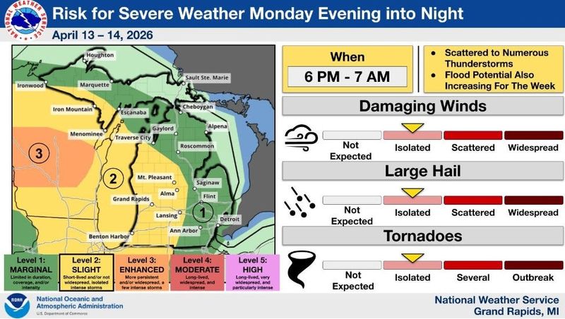
Most of Michigan is expected to see rounds of thunderstorms early this week, beginning Monday night, April 13. Greater Lansing residents could see high winds, a possible isolated tornado, 1-inch hail and flooding.
“The first of what looks to be numerous rounds of thunderstorms this week moves in this evening and tonight (April 13). Both severe weather and flooding are a concern. Residents along rivers and creeks need to pay close attention to water levels this week.” Grand Rapids National Weather Service posted on X on April 13.

Monday night storms, April 13, are expected to intensify into Tuesday, April 14. The Lower Peninsula, including the Greater Lansing area, has the greatest risk for severe weather.
In Lansing, rain and thunderstorms are forecast to develop as early as 6 p.m. on Monday, April 13, and persist until around 8 a.m. on Tuesday, April 14.
Storms are expected to pick up again in the afternoon on Tuesday, April 13. On Tuesday, a high of 63 degrees is expected.
By 1 p.m. on Wednesday, Lansing is estimated to see at most 1.3 inches of rain accumulate, according to the NWS Probabilistic Precipitation Portal.
Here’s the live radar, warning map to track local hazards and steps to prepare for a flood.
Where is rain moving? Michigan live radar
Current watches, warnings and advisories in Michigan
To view the details of a warning, watch or advisory in Michigan click on any shaded region shown on the map.
The bright green shading indicates flood warnings, while the red lines indicate a flash flood warning.
How should I prepare for a flood?
For those who live water bodies or rivers such as the Red Cedar River or Grand River, here are ways to prepare if water overflows, according to the NWS:
Contact Sarah Moore @ smoore@lsj.com
This article originally appeared on Lansing State Journal: Lansing region expected to see severe storms, heavy rain this week
Reporting by Sarah Moore, Lansing State Journal / Lansing State Journal
USA TODAY Network via Reuters Connect