The Atlantic hurricane season has arrived and with it the iconic rotating list of hurricane names.
“Since 1953, Atlantic tropical storms had been named from lists originated by the National Hurricane Center. They are now maintained and updated by an international committee of the World Meteorological Organization,” the National Hurricane Center said on X on May 9.

There are six lists of 21 names and each list is repeated every six years. The names are updated by the World Meteorological Organization and chosen to be noticeable. They are of English, French and Spanish origin to reflect the coverage of storms in the Atlantic Ocean, Caribbean Sea and Gulf of Mexico, according to the WMO.
Names can also be withdrawn from the lists if the storm caused mass damage and fatalities. For instance, Beryl, Helene and Milton are retired names because of hurricanes in 2024.
“The official hurricane season for the Atlantic basin is from June 1 to November 30, but tropical cyclone activity sometimes occurs before and after these dates, respectively,” the National Oceanic Atmospheric Administration said. “The peak of the Atlantic hurricane season is September 10, with most activity occurring between mid-August and mid-October.”
Michigan is far removed from hurricane developments but has experienced residual weather, and in the late 1990s recorded a storm over Lake Huron that resembled hurricane conditions, according to the NWS.
While hurricane trackers are clear for now, here is the 2025 Atlantic hurricane name list:
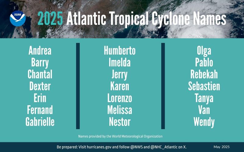
What are the hurricane names listed for 2025?
Here are the 2025 Atlantic hurricane names, updated by the World Meteorological Organization:
The first letter of each name follows the alphabet, though the list excludes names beginning with Q, U, X, Y and Z.
“The list of hurricane names covers only 21 letters of the alphabet as it is difficult to find six suitable names (one for each of the 6 rotating lists) starting with Q, U, X, Y and Z,” the WMO said.
Michigan’s 1996 Lake Huron (almost) hurricane
While Michigan has never reported a hurricane – defined as a tropical cyclone with sustained winds greater than 74 mph – there was a unique storm over Lake Huron reminiscent of a hurricane.
On Sept. 11-15, 1996, a low pressure system hovered over Lake Huron and developed bands of spiral clouds and an “eye” several miles wide. Winds were recorded as high as 73 mph, according to the NWS based in Detroit. In the media coverage, the odd event was nicknamed “hurroncane.”
“It is believed that the warm waters of Lake Huron and associated low level instability over the lake were, to a large extent, the major contributing factors in this storm’s evolution. The storm went on to form a broad cyclonic circulation, including the “spiral bands and eye,” typically seen in hurricanes,” the NWS said.
What is the difference between a tropical storm and a hurricane?
From the NWS’ glossary, here are how these tropical weather events are defined:
What happens if all the names are used?
The WMO includes a supplemental list in the event a name needs to be filled or replaced. Here’s the list of back-up hurricane names:
Contact Sarah Moore @smoore@lsj.com
This article originally appeared on Lansing State Journal: Atlantic hurricane season 2025: Will you share a name with a hurricane?
Reporting by Sarah Moore, Lansing State Journal / Lansing State Journal
USA TODAY Network via Reuters Connect