“Necessity is the mother of invention.” Plato
By Theresa McGregor

My grandfather was born in 1893 in Bronson, Michigan, a small town just west of I-69 at the Indiana border. He started and finished his formal education in a one-room schoolhouse which he left after the eighth grade. One of his first jobs was for the Lutz and Schram Pickle Company. This job required him to travel around the state. That’s how he met my grandmother who was from Swartz Creek, MI. Grandpa worked in the automotive industry in Flint, MI for most of the rest of his life. In the fifties, he worked for General Motors Institute conducting training seminars in Customer Relations for service personnel in GM dealerships.

This job required him to drive not just around Michigan, but around the whole country. These were the days before the interstate highway system, Holiday Inns and McDonald’s. It was the days of two-lane highways, one-lane bridges, and roadside picnic areas. He and my grandmother traveled around 46 of the then 48 states, spending a short time in each seminar town.


They stayed in small hotels and motels and sometimes had a room with a kitchenette. Of course, they did as much sightseeing as they could and left hundreds of pictures of the sights. If you spent time analyzing all the pictures and reading up on the history behind the buildings and statues, you would certainly run the American History category on Jeopardy. Grandma was easily the most photographed woman of the fifties.

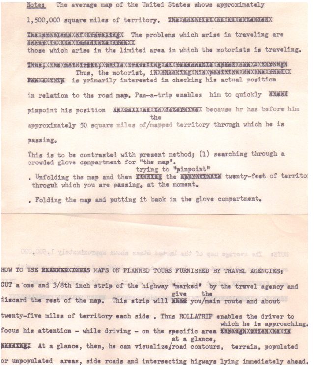
After he retired, Grandpa spent most of his time reading the Great Books and writing about what he had read. As I was going through some of his papers, I came upon a typewritten sheet with strips of maps attached with a paper clip.

The paper was a description of a system he called Roll-a-Trip. He proposed cutting out the route in a one-inch strip. He would mount two spools across from each other on the steering wheel, wind the map strip around the left spool and stretch it under a magnifying glass to the right spool. As he traveled a certain number of miles, he would wind the map one inch. He would always have the 50 square miles of the road he was on right in front of him. He could keep track of where he was going without having to keep looking at a huge map. Rhode Island, the smallest state covered an area of over 1200 square miles while Texas, the largest state covered over 200,000 square miles. He described how he could mount a flashlight for night reading and how he could write names of hotels and restaurants on the map.
Suddenly, it came to me “Grandpa invented GPS!”

My amazement lasted about one day. At the time, I was planning a trip to England and Wales. One of our stops was going to be Hay-on-Wye, a town widely recognized as the used book capital of Britain. I was browsing the internet for used bookstores when I came upon “Mostly Maps”, a store selling antique maps and prints. Browsing through the maps available for sale, I came across an odd-looking one. It was a series of scrolls that depicted portions of a road with various landmarks on it. It was a ‘strip map’ from the early 1700s used by stagecoach drivers and it was the map of the journey from Welshpool to Caernarvon. Welshpool just happened to be on our itinerary.
Grandpa had not invented GPS after all. He was just channeling a 16th-century stagecoach driver. All the old saws flooded into my mind. “Great minds think alike”. “There is nothing new under the sun”. “Necessity is the mother of invention|. And, as Isaac Newton said, “If I see further, it is because I stand on the shoulders of giants.
You can see more examples of these maps at https://www.mostlymaps.com/en-GB//page_906.
Here is a copy of my grandfather’s original typewritten description with his notes.