
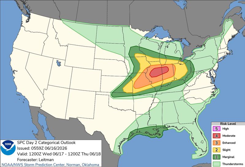
Indianapolis is under an increased risk of severe weather that could produce strong tornadoes Wednesday, as well as “very large hail,” localized flooding and damaging straight line wind gusts in excess of 80 mph.
The worst of the storms, according to the National Weather Service, are expected to slam into the Midwest beginning Wednesday afternoon June 17 into early Thursday morning.

In a Tuesday morning video posted on social media, NWS meteorologist Casey Crosbie warned tornadoes capable of producing 111-135 mph winds or higher were possible June 17.
The Storm Prediction Center in Norman, Oklahoma, Crosbie said, shows severe weather over large portions of central Indiana poses a significant threat that includes “EF2+ tornadoes, wind gusts of over 75 mph and 2-inch or greater diameter hail.”
NWS issues hazardous weather outlook for central Indiana for June 16-17, 2026
NWS forecasters on June 16 issued a hazardous weather outlook for central Indiana, warning that some isolated thunderstorms could produce damaging winds and large hail starting Tuesday afternoon in Marion and surrounding counties.
Storms could move quickly, warns AccuWeather forecaster
Meteorologists are encouraging Hoosiers to keep a close eye on the weather, not only due to the potential intensity of the storms but because of how fast they could travel.
“The thunderstorms Wednesday and Wednesday night could be rapidly moving, perhaps at 70 mph. This could result in relatively little time to react to warnings before the storms hit,” said Dan DePodwin with AccuWeather in a message to IndyStar.
DePodwin said Wednesday’s chances for severe weather were the result of unusually intense low pressure sweeping into the Midwest.
Plentiful warm and humid air will interact with the storm, he explained, setting the stage for widespread damaging thunderstorms.
AES Indiana monitoring conditions Wednesday, June 17
In an email sent to AES Indiana customers Tuesday afternoon, the utility company stated its crews are monitoring weather conditions ahead of Wednesday’s anticipated severe storms.
“We are fully staffed and prepared to respond to outages if they occur,” an unnamed spokesperson for AES wrote, encouraging Hoosiers prepare in advance for bad weather.
Hoosiers can track power outages in the Indianapolis area online with AES Indiana’s outage map.
Live Indianapolis, Indiana weather radar
What time will severe weather hit central Indiana on June 17, 2026? How long will it last?
According to NWS, severe weather on June 17 could move into central Indiana beginning 2 p.m. Wednesday and last until 2 a.m. Thursday, June 18.
Crosbie on social media offered this more nuanced timeline of what Hoosiers could see during the mid-afternoon to late evening hours of June 17:
‘Cluster of supercells’ headed for Indiana on June 17. When could severe weather hit?
In one forecast model, Crosbie said a cluster of supercells will move across central Indiana from 2-8 p.m. on Wednesday, June 17.
That will be followed by “a large line of thunderstorms with the potential for wind gusts in excess of 80 mph and isolated tornadoes until 1 or 2 a.m. (Thursday),” Crosbie said.
Crosbie urged Hoosiers to have a plan in place ahead of the severe weather.
Weather forecast continues after photo gallery of storm damage from June 11 tornado impacting Andrean High School in Merrillville, Indiana.
Weather forecast for central Indiana, June 16-19, 2026, per NWS
Tuesday: Partly sunny, with a high near 78 and a low around 57. A chance of showers and thunderstorms before 3 p.m., then showers likely and possibly a thunderstorm between 3 p.m. and 4 p.m., then a chance of showers and thunderstorms after 4 p.m. Southwest wind 6 to 14 mph, with gusts as high as 23 mph. Chance of precipitation is 60%.
Wednesday: Partly sunny, with a high near 81. A slight chance of showers between 1 p.m. and 2 p.m., then a chance of showers and thunderstorms after 2 p.m. Some storms could be severe. South wind 6 to 14 mph, with gusts as high as 24 mph. Chance of precipitation is 40%.
Wednesday night: A chance of showers and thunderstorms, then showers and possibly a thunderstorm after 8 p.m. Some storms could be severe and bring heavy rainfall. Low around 68. Breezy, with a south southwest wind 14 to 20 mph, with gusts as high as 33 mph. Chance of precipitation is 100%. New rainfall amounts between three quarters and one inch possible.
Thursday: Showers likely before 8 a.m. Mostly sunny, with a high near 77 and a low around 59. West wind 11 to 14 mph, with gusts as high as 28 mph. Chance of precipitation is 60%.
Friday, Juneteenth: Sunny, with a high near 78 and a low around 59. Light west northwest wind increasing to 6 to 11 mph in the morning. Winds could gust as high as 20 mph.
Start your morning with the top Indy news delivered straight to your inbox with IndyStar’s Daily Briefing. Sign up for free at indystar.com/newsletters.
John Tufts covers trending and breaking news for IndyStar and Midwest Connect. Send him a news tip at John.Tufts@IndyStar.com. Find him on BlueSky at JohnWritesStuff.
This article originally appeared on Indianapolis Star: Indiana at risk for 80 mph winds, large hail and tornadoes Wednesday
Reporting by John Tufts, Indianapolis Star / Indianapolis Star
USA TODAY Network via Reuters Connect
By John Tufts, Indianapolis Star | USA TODAY Network