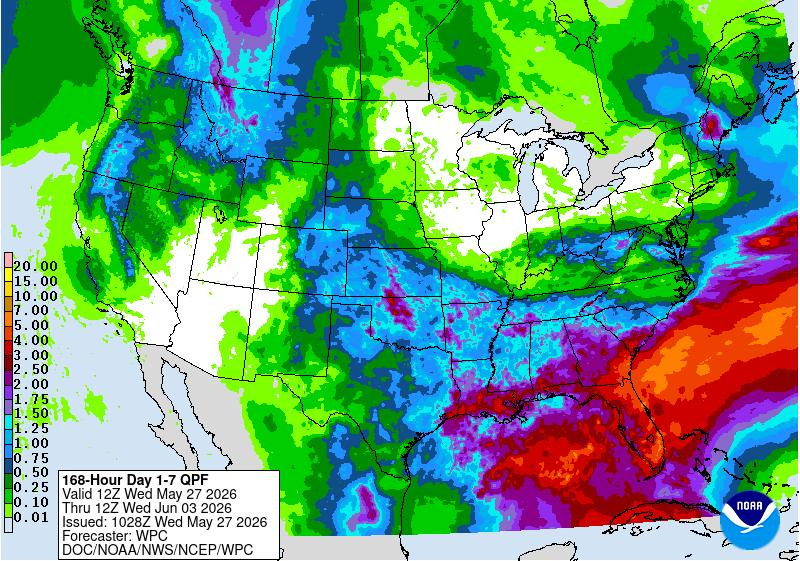
Storm chances are ramping up across Florida, although for some areas, rain is already being felt.
While the rain is welcome relief to the drought-stricken state, too much at one time could cause localized flash flooding in the coming days to some areas.

Don’t expect the rain to make it feel better outside.
“A general flow from the tropics will continue to pump very muggy air across Florida,” said Alex DaSilva, AccuWeather lead hurricane expert via email May 27.
➤ Weather alerts via text: Sign up to get updates about current storms and weather events by location
An “unsettled and humid weather pattern kicks off on Thursday (May 28), lasting at least into early next week,” according to the National Weather Service.
➤ Maps show where severe storms are possible from Virginia to Texas
Weather alerts currently in place across Florida
Radar shows location of storms moving through Florida
Will it rain in Florida this week, weekend?
Chances of rain will be high — 70% to 90% — May 28 through May 30 for the I-10 corridor and the central and eastern portions of Florida’s peninsula, according to the Florida Division of Emergency Management.
There’s a medium chance of rain — 30% to 50% — for coastal Panhandle and western peninsula locations.
“While there is currently no organized risk of severe weather associated with thunderstorms that develop this week, a few locally strong storms containing isolated damaging winds cannot be ruled out,” according to the Florida Division of Emergency Management.
How hot will it get in Florida this week?
The rain won’t bring any respite from the high temps Florida has seen lately, including over the Memorial Day weekend.
“A general flow from the tropics will continue to pump very muggy air across Florida,” DaSilva said.
Summer-like heat and humidity will persist through May 30, with daytime high temperatures generally in the low-mid 90s across the state, according to the Florida Division of Emergency Management.
The “feels-like temperatures” will climb into the mid- to upper 90s through May 30, with some locations briefly exceeding 100 degrees, especially in North and Central Florida.
Is there a tropical storm developing off Florida?
“We will have to keep a close eye on the eastern Gulf or southwestern Atlantic for possible development during the first two weeks of June,” DaSilva said.
➤ How do the tropics look today? See latest from National Hurricane Center
“I think the chance is very low at this time and we currently don’t have an area explicitly highlighted … but this will be the area to watch.
“Sea-surface temperatures are warmer than average in these areas. If anything were to develop, it likely would move north or northeast. As a result, we will need to keep a close eye on Florida during the first two weeks of June,” DaSilva said.
“Even if nothing develops, the next few weeks do look wetter overall for Florida, which will help with the drought. We will need a lot of rain to bust the drought, but this pattern will help.”
Weather radar, forecast for Pensacola, Florida
Multiple rounds of heavy rainfall leading to possible flash flooding will occur over the next several days, according to the National Weather Service Mobile.
“The main concern over the next few days will be heavy rainfall. The slow-moving nature of these storms, as well as the deep moisture in place, will lead to storms being efficient rainfall producers (rates potentially as high as 2-3 inches an hour.”
Highs will generally top out in the mid to upper 80s throughout the period. Lows will be mild and humid, with temperatures only dropping into the upper 60s to low 70s inland and the low to mid 70s closer to the coast.
A high risk of rip currents will continue through May 28, potentially lowering to a moderate risk for May 29 and into the weekend.
➤ Follow National Weather Service Mobile on X
Weather radar, forecast for Tallahassee, Florida
“Numerous showers and thunderstorms are expected each day through the next week,” according to the National Weather Service Tallahassee.
“Gusty winds, torrential downpours, and frequent lightning will be the primary threats from storms. Localized flash flooding is possible, especially in areas that have seen heavy rain recently.”
Widespread rainfall totals over the next seven days is about 2 to 3 inches. Some areas by early next week could see rainfall totals of 4 to 6 inches.
Highs are expected to be in the mid to upper 80s through the weekend.
➤ Follow the National Weather Service Tallahassee on X
Weather radar, forecast for Jacksonville, Florida
There’s a chance for thunderstorms May 27, with a few strong storms possible.
Expect “waves of showers and thunderstorms” beginning May 28. “Heavy rainfall and localized flooding will be a concern.” Widespread rainfall totals of 2 to 4 inches are expected through June 2, according to the National Weather Service Jacksonville.
High temperatures through the end of the week will rise into the upper 80s and lower 90s with heat index values in the upper 90s and even reaching over 100 degrees in some areas.
The heat index could climb between 95 and 105 through May 29.
➤ Follow the National Weather Service Jacksonville on X
Weather radar, forecast for Daytona Beach, Florida
An unsettled and humid weather pattern kicks off May 28, lasting at least into early next week. High coverage of afternoon and evening storms is expected, even at the coast, according to the National Weather Service Melbourne.
Deep tropical moisture … is forecast to move north from the Caribbean into Florida from May 28 through the weekend.
Total rainfall amounts of 1.5 to 2.5 inches appear most likely through Sunday.
There is at least a limited threat of localized flooding in urban and poorly drained areas from repeated rounds of heavy rain.
Warm and muggy conditions will prevail, with near-normal highs in the upper 80s to near 90 and heat index readings topping out just shy of 100 degrees.
➤ Follow the National Weather Service Melbourne on X
Weather radar, forecast for Melbourne, Florida
An unsettled and humid weather pattern kicks off May 28, lasting at least into early next week. High coverage of afternoon and evening storms is expected, even at the coast, according to the National Weather Service Melbourne.
Deep tropical moisture … is forecast to move north from the Caribbean into Florida from May 28 through the weekend.
Total rainfall amounts of 1.5 to 2.5 inches appear most likely through Sunday.
There is at least a limited threat of localized flooding in urban and poorly drained areas from repeated rounds of heavy rain.
Warm and muggy conditions will prevail, with near-normal highs in the upper 80s to near 90 and heat index readings topping out just shy of 100 degrees.
➤ Follow the National Weather Service Melbourne on X
Weather radar, forecast for Port St. Lucie, Florida
An unsettled and humid weather pattern kicks off May 28, lasting at least into early next week. High coverage of afternoon and evening storms is expected, even at the coast, according to the National Weather Service Melbourne.
Deep tropical moisture … is forecast to move north from the Caribbean into Florida from May 28 through the weekend.
Total rainfall amounts of 1.5 to 2.5 inches appear most likely through Sunday.
There is at least a limited threat of localized flooding in urban and poorly drained areas from repeated rounds of heavy rain.
Warm and muggy conditions will prevail, with near-normal highs in the upper 80s to near 90 and heat index readings topping out just shy of 100 degrees.
➤ Follow the National Weather Service Melbourne on X
Weather radar, forecast for West Palm Beach, Florida
“An unsettled weather pattern will bring increasing chances for showers and thunderstorms across South Florida, starting tomorrow (May 28), with increasing potential for heavy downpours and localized flooding, according to the National Weather Service Miami.
➤ South Florida weather could bring thunderstorms, increased flood risk
“Given the likelihood of having multiple days of flooding concerns, a close eye will be kept on upcoming guidance in case a flood watch becomes necessary.”
Afternoon highs should continue to hit the upper 80s to around 90 along the East Coast. Heat indices will peak in the upper 90s to around 100 across the East Coast, despite the onset of the rainy pattern.
➤ Follow the National Weather Service Miami on X
Weather radar and forecast for Miami, Florida
“An unsettled weather pattern will bring increasing chances for showers and thunderstorms across South Florida, starting tomorrow (May 28), with increasing potential for heavy downpours and localized flooding, according to the National Weather Service Miami.
➤ South Florida weather could bring thunderstorms, increased flood risk
“Given the likelihood of having multiple days of flooding concerns, a close eye will be kept on upcoming guidance in case a flood watch becomes necessary.”
Afternoon highs should continue to hit the upper 80s to around 90 along the East Coast. Heat indices will peak in the upper 90s to around 100 across the East Coast, despite the onset of the rainy pattern.
➤ Follow the National Weather Service Miami on X
Weather radar, forecast for Naples, Florida
“An unsettled weather pattern will bring increasing chances for showers and thunderstorms across South Florida, starting tomorrow (May 28), with increasing potential for heavy downpours and localized flooding, according to the National Weather Service Miami.
➤ South Florida weather could bring thunderstorms, increased flood risk
“Given the likelihood of having multiple days of flooding concerns, a close eye will be kept on upcoming guidance in case a flood watch becomes necessary.”
Afternoon highs should continue to hit the mid 90s over west coast areas. Heat indices will peak in the mid 100s over Southwest Florida, despite the onset of the rainy pattern.
➤ Follow the National Weather Service Miami on X
Weather radar, forecast for Fort Myers, Florida
An increasingly wet pattern is expected late in the week through early next week.
Thunderstorms are expected to develop each day, mainly in the afternoon and evening hours today, then at almost anytime May 28 through at least June 2, according to the National Weather Service Tampa Bay.
➤ Follow the National Weather Service Tampa Bay on X
Weather radar, forecast for Sarasota, Florida
An increasingly wet pattern is expected late in the week through early next week.
Thunderstorms are expected to develop each day, mainly in the afternoon and evening hours today, then at almost anytime May 28 through at least June 2, according to the National Weather Service Tampa Bay.
➤ Follow the National Weather Service Tampa Bay on X
Weather radar, forecast for Tampa, Florida
An increasingly wet pattern is expected late in the week through early next week.
Thunderstorms are expected to develop each day, mainly in the afternoon and evening hours today, then at almost anytime May 28 through at least June 2, according to the National Weather Service Tampa Bay.
➤ Follow the National Weather Service Tampa Bay on X
Weather radar, forecast for Orlando, Florida
Storm chances begin to ramp up late May 27 near and west of Orlando. A few storms this afternoon and evening may become strong with wind gusts exceeding 50 mph and frequent lightning, according to the National Weather Service Melbourne.
An unsettled and humid weather pattern kicks off May 28, lasting at least into early next week. High coverage of afternoon and evening storms is expected, even at the coast.
Deep tropical moisture … is forecast to move north from the Caribbean into Florida from May 28 through the weekend.
Total rainfall amounts of 1.5 to 2.5 inches appear most likely through Sunday.
There is at least a limited threat of localized flooding in urban and poorly drained areas from repeated rounds of heavy rain.
Warm and muggy conditions will prevail, with near-normal highs in the upper 80s to near 90 and heat index readings topping out just shy of 100 degrees.
➤ Follow the National Weather Service Melbourne on X
Stay informed. Get weather alerts via text
What’s next?
We will continue to update our weather coverage as conditions warrant. Download your local site’s app to ensure you’re always connected to the news. And look for our special subscription offers here.
Cheryl McCloud is a journalist for the USA TODAY Network-Florida’s service journalism Connect team. You can get all of Florida’s best content directly in your inbox each weekday day by signing up for the free newsletter, Florida TODAY, at https://tallahassee.com/newsletters.
This article originally appeared on Tallahassee Democrat: Who’s ready for some rain, but will Florida soon see flooding?
Reporting by Cheryl McCloud, USA TODAY NETWORK – Florida / Tallahassee Democrat
USA TODAY Network via Reuters Connect