AccuWeather forecasters warn that the fire weather conditions responsible for the fires currently spreading over northeastern Florida and Georgia are likely to persist through the summer.
Florida’s wildfire risks are currently focused along the northern portion of the state, in a swath that stretches from the Louisiana Gulf Coast, through the Carolinas and into eastern West Virginia.

Seven wildfires have been reported in Santa Rosa and Okaloosa counties over the past week. Four were still listed as active as of 10 a.m. on April 23, according to the Florida Forest Service.
Those fires do not include a brush fire that broke out along Scenic Highway in Pensacola on April 22. The fire led to the closure of Scenic Highway just south of Scenic Court for a few hours.
Nearly 1,800 wildfires have been reported across Florida, burning more than 103,000 acres since Jan. 1, according to Florida Forest Service data.
A combination of extreme drought conditions throughout much of the state and higher-than-normal temperatures has been the primary drivers behind the wildfires.
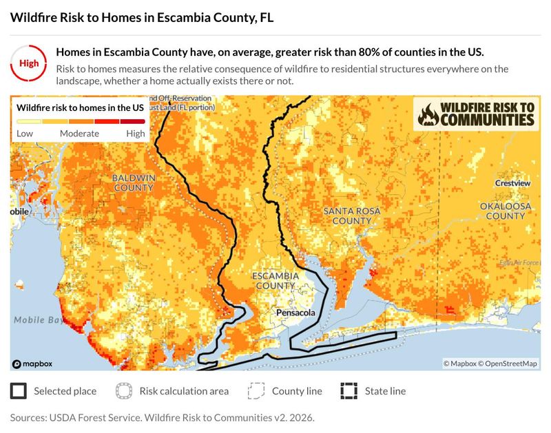
What’s the risk of wildfires in Pensacola, Escambia County?
Pensacola and the wider Escambia County are in better positions than other counties in the state, but the area’s risk is still elevated compared to other parts of the country.
Here’s Escambia County’s fire danger index:
Escambia County has a higher risk of wildfire than 80% of the rest of the counties in the United States, according to USDA data. It has a greater risk than only 35% of the counties in Florida.
KBDI values higher than 400 are associated with very dry soils and vegetation. While it doesn’t address the likelihood of a wildfire breaking out, it does mean that fires could spread more easily due to the dry conditions.
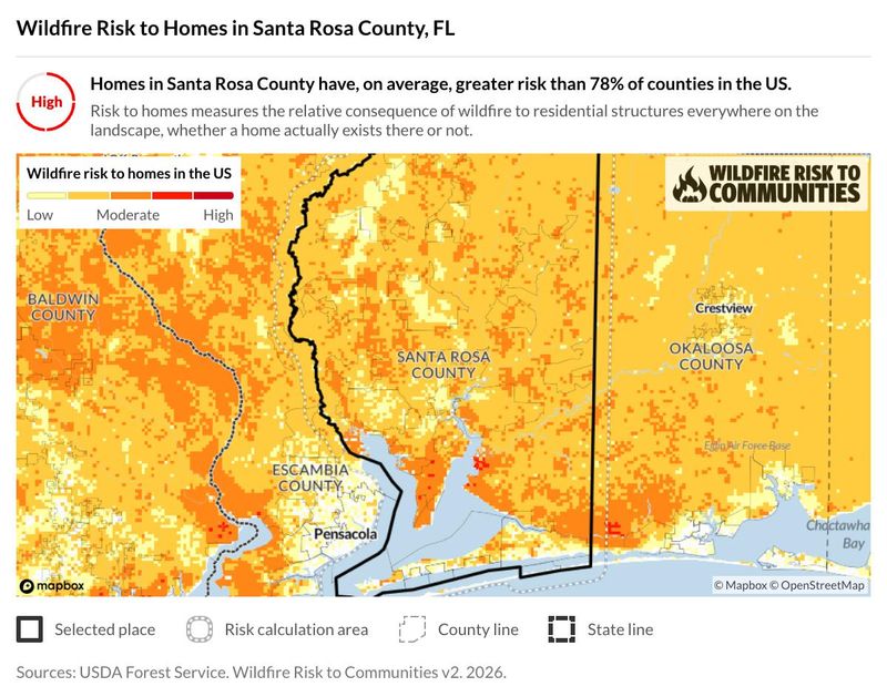
What’s the risk of wildfires in Santa County?
Santa Rosa County officials are already urging residents to take extra precautions when it comes to campfires, cooking fires and when parking vehicles in tall grass.
Here’s Santa Rosa County’s fire danger index:
Homes in Santa Rosa County have a greater wildfire risk than 78% of other counties in the U.S. and 27% of counties in Florida.
While Santa Rosa has a higher KBDI than Escambia, it isn’t in the extreme range, which is typically associated with values above 600.
Is there a burn ban in place in your area?
The Florida Forest Service has an interactive burn ban map that shows which counties have bans in effect.
Florida currently has 42 counties with burn bans in place. Almost all of the counties in the Panhandle are under a burn bank, excluding Escambia, Santa Rosa, Okaloosa and Jackson counties.
Florida drought index map
The Keetch-Byram drought index (KBDI) is a continuous reference scale for estimating the dryness of the soil and duff layers.
The range of the index is determined by assuming that there is 8 inches of moisture in a saturated soil that is readily available to the vegetation.
This map is updated once daily at 1 p.m. CT.
Florida fire danger map
The Florida fire danger index estimates how likely a wildfire is to start on a given day. It uses a combination of weather and fuel conditions, such as recent and forecasted rainfall, temperature, wind speeds and relative humidity, to calculate the index.
Map shows location of active wildfires, smoke impacts across Florida
As of 11 a.m. April 23, there were 127 active wildfires burning 25,210 acres across Florida.
According to the Florida Department of Agriculture and Consumer Services, between Jan. 1 and April 19 in Florida:
Smelling smoke? See air quality across Florida
According to the EPA, despite the number of wildfires and associated smoke, air quality in the state range from good to moderate.
➤ See breakdown of air quality by Florida county
Interactive map: Enter your address to find closest wildfire risks
Stay informed. Get weather alerts via text
This article originally appeared on Pensacola News Journal: Florida wildfire maps show where Pensacola’s risk is highest
Reporting by Brandon Girod and Cheryl McCloud, Pensacola News Journal / Pensacola News Journal
USA TODAY Network via Reuters Connect