A potentially historic and record-breaking snowfall could hit Michigan’s Upper Peninsula and impact northern Michigan as a winter storm is expected to move into the state during the evening of Saturday, March 14 through Monday night, March 16, according to the National Weather Service.
Upper Peninsula winter storm forecast

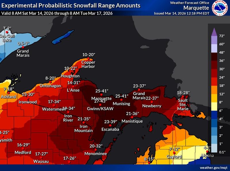
Snowfall between 1 and 3 feet is possible across the Upper Peninsula, which is under a winter storm warning until 2 a.m. Tuesday, March 17. The highest snow amounts are expected central and eastern areas.
Strong winds could lead to blizzard conditions, especially Sunday night into Monday morning. Wind gusts could be as high as 50 mph in most of the region and as high as 60 mph in the Keweenaw Peninsula and by the lakeshore.
Snow is expected to be widespread and heavy on Sunday, with the worst conditions expected over the east, particularly near Lake Superior where travel will be impossible. Moderate to heavy snowfall and strong winds are expected to gradually taper off late Monday.
The NWS warns it will be dangerous to impossible to travel through the area and to expect power outages, tree damage and prolonged recovery time. It suggests people should delay all travel and use extreme caution if travel is absolutely necessary. Motorists should keep an extra flashlight, food and water in their vehicles in case of an emergency.
Northern Michigan winter storm forecast
South of the Mackinac Bridge, much of northern Michigan is under a winter storm watch though Monday.
Heavy mixed precipitation is possible with snow and sleet accumulations between 5 and 12 inches in Antrim, Benzie, Grand Traverse, Kalkaska, Leelanau, Manistee, Otsego and Wexford counties. Ice accumulations of more than a quarter-inch are possible, along with wind gusts up to 45 mph.
Alcona, Alpena, Arenac, Crawford, Gladwin, Iosco, Missaukee, Ogemaw and Roscommon counties could see heavy mixed precipitation, ice accumulations exceeding a quarter-inch and wind gusts up to 40 mph. Snow totals of 3 to 7 inches are possible.
Power outages, tree damage and difficult travel are also expected in northern Michigan.
Be prepared for whatever is in Michigan’s weather forecast with live doppler radar from the National Weather Service below. We also have resources on how to check your power outage status and prepare for floods.
Michigan weather radar
(Hit refresh on your browser for the latest radar loop.)
This article originally appeared on Detroit Free Press: Michigan winter storm could make travel impossible in Upper Peninsula
Reporting by Tanya Wildt, Detroit Free Press / Detroit Free Press
USA TODAY Network via Reuters Connect