The blast of Arctic air that settled over Michigan this past weekend led to two cities tying low-temperature records on Sunday, Dec. 14.
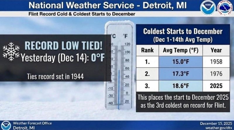
On Dec. 15, the Detroit National Weather service announced on X that Flint tied a record low at zero degrees Sunday morning, Dec. 14, originally set in 1944.

“This places the start to December 2025 at the 3rd coldest on record for Flint,” the Detroit NWS said on X.
Marquette tied a record low-high temperature of 7 degrees, matchihng the previous record set in 1985, according to the NWS.
In addition to temperature records, Sault Ste. Marie saw a record daily maximum snowfall of 7.2 inches on Dec. 14, surpassing the old record of 6.9 inches for that date set in 1963.
Weather officials predict a warming trend this week in Michigan, with highs ranging in the 30s-40s statewide. On Thursday, Dec. 18, Detroit is expected to see a high of 46 degrees.
As warmer air moves into Michigan, here’s a look at how cold it got on Sunday, Dec. 14:
How cold did it get yesterday in Michigan?
Here’s a list of the highs and lows observed across Michigan on Sunday, Dec. 14:
Contact Sarah Moore @ smoore@lsj.com
This article originally appeared on Lansing State Journal: Last of Arctic blast leads to low-temperature records. How cold it got
Reporting by Sarah Moore, Lansing State Journal / Lansing State Journal
USA TODAY Network via Reuters Connect