Imelda became the fourth hurricane of the 2025 Atlantic hurricane season early Tuesday morning, but a rare Fujiwhara interaction with Humberto will prevent the storm from making landfall in the United States.
“This is a case where the rare Fujiwhara Effect will help steer Imelda away from the U.S.,” AccuWeather Lead Hurricane Expert Alex DaSilva said.

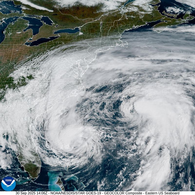
Florida and Georgia will receive the brunt of Hurricane Imelda’s impacts. Meteorologists warn that the storm will still bring dangerous surf, rip currents and coastal flooding to Florida. Florida’s eastern coast will also see tropical rain and winds.
Spaghetti models for Hurricane Imelda show the storm tracking east through Friday, passing directly over Bermuda, before turning northeast and fizzling out over the Atlantic.
Imelda will bring rip currents, heavy rain to parts of Florida
Imelda and another non-tropical disturbance will work together to bring heavy rainfall to Atlantic coastal areas from Florida to North Carolina and southern Virginia, according to forecasters.
“Imelda and the moisture plume will lead to locally heavy rain across Georgia and the Carolinas into Tuesday morning,” DaSilva said. “Some of the rain can be heavy enough to lead to isolated flash flooding.”
Through Wednesday, Florida isn’t forecast to see much impacts from either disturbances, but the National Weather Service predicts that Florida’s eastern coastline will see as high as 6 inches of rain along in some coastal areas over the next five days.
“Along with localized flash flooding, there is the potential for quick-moving thunderstorms along the coast that can spawn waterspouts and tornadoes,” AccuWeather Senior Storm Warning Meteorologist Eddie Walker said.
Flood warnings, rip current statements and high surf advisories have already been issued in a number of Florida counties from Palm Beach, Broward and Miami Dade counties to Florida northeast beaches.
Hurricane Imelda 10 a.m. advisory:
At 10 a.m. CT, the center of Hurricane Imelda was located near latitude 29.1 North, longitude 76.6 West. Imelda is moving toward the northeast near 7 mph (11 km/h), according to the National Hurricane Center.
A generally east-northeastward motion at a faster forward speed is expected over the next couple of days. On the forecast track, the center of the hurricane should continue to move away from the Bahamas today and be approaching Bermuda Wednesday afternoon.
Maximum sustained winds have increased to near 80 mph (130 km/h) with higher gusts. Additional strengthening is forecast during the next 48 hours.
Hurricane-force winds extend outward up to 45 miles (75 km) from the center and tropical-storm-force winds extend outward up to 185 miles (295 km). The estimated minimum central pressure is 980 mb (28.94 inches).
Hurricane Imelda watches, warnings and impacts
A Hurricane Watch is in effect for:
A Hurricane Watch means that hurricane conditions are possible within the watch area. A watch is typically issued 48 hours before the anticipated first occurrence of tropical-storm-force winds, conditions that make outside preparations difficult or dangerous.
WIND: Hurricane conditions are expected over Bermuda by Wednesday evening, with tropical storm conditions possible by Wednesday afternoon.
RAINFALL: Across Bermuda, 2 to 4 inches (50 to 100 mm) of rainfall are expected from Wednesday into Thursday, which could lead to flash flooding.
STORM SURGE: In Bermuda, a dangerous storm surge is expected to produce coastal flooding in areas of onshore winds. The surge will be accompanied by large and damaging waves.
Minor coastal flooding is possible in areas of onshore winds over the Southeastern U.S. coastline. The water could reach the following heights above ground somewhere in the indicated areas if the surge occurs over the next several high tide cycles…
SURF: Swells generated by Hurricane Imelda and Hurricane Humberto are affecting the Bahamas and are currently spreading to much of the U.S. east coast. These swells are likely to cause life-threatening surf and rip current conditions. Please consult products from your local weather office.
Hurricane Imelda spaghetti models
Hurricane Humberto 10 a.m. advisory
At 10 a.m. CT, the center of Hurricane Humberto was located near latitude 33.0 North, longitude 69.9 West. Humberto is moving toward the north-northwest near 18 mph (30 km/h).
A turn to the north and north-northeast is expected today, followed by a much faster east-northeast motion on Wednesday and Thursday. On the forecast track, the center of Humberto will pass west of, and then north of Bermuda today and Wednesday.
Maximum sustained winds have decreased to near 80 mph (130 km/h) with higher gusts. Continued weakening is forecast and Humberto is expected to become a strong extratropical system on Wednesday.
Hurricane-force winds extend outward up to 70 miles (110 km) from the center and tropical-storm-force winds extend outward up to 205 miles (335 km). The minimum central pressure is 979 mb (28.91 inches) as indicated by an Air Force Hurricane Hunter dropsonde.
Hurricane Humberto impacts
SURF: Swells from Humberto are likely to cause dangerous surf and life-threatening rip current conditions, affecting beaches of the northern Caribbean, Bahamas, Bermuda, and much of the east coast of the United States over the next several days. Please consult products from your local weather office.
WIND: Gusty winds are possible over Bermuda within outer rainbands today into Wednesday.
RAINFALL: Hurricane Humberto is expected to bring rainfall of 1 to 2 inches – 25 to 50 mm – to Bermuda today.
Hurricane Humberto spaghetti models
List of named storms from the 2025 Atlantic hurricane season
This article originally appeared on Pensacola News Journal: Hurricane Imelda forms but will avoid US landfall thanks to Humberto. See Florida impacts
Reporting by Brandon Girod, Pensacola News Journal / Pensacola News Journal
USA TODAY Network via Reuters Connect