Hurricane Lorena, which made landfall in northern Mexico early Thursday, Sept. 4, has weakened into a post-tropical cyclone and its remnants are now moving through the Desert Southwest.
The storm rapidly intensified overnight on Sept. 2–3 but is expected to weaken quickly, becoming a tropical storm later on Sept. 4 and degenerating into a remnant low by Sept. 6, the National Hurricane Center said.

Moisture is currently moving into El Paso and Far West Texas and will bring showers through early Saturday, Sept. 6. The National Weather Service in El Paso warns of possible localized flash flooding, flash flooding near burn scars and frequent lightning, but there is currently no flood watch or advisory issued for the area.
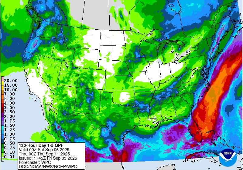
The most likely rainfall total for the region is under half an inch total, though the National Weather Service notes a higher-end scenario could bring 2 to 4 inches in some areas, mainly west of Rio Grande Valley.
“Tropical Storm Lorena’s moisture will flow across the area allowing for light rain showers across parts of the area,” the National Weather Service wrote on Friday, Sept. 5. “Best locations for rain will be along the International Border. There is a chance thunderstorms could occur across the area mountains, but that depends on if there are some breaks in the clouds.”
The Hill Country and surrounding areas could expect several inches of rain, as the tropical moisture interacts with a cold front set to reach the state.
Rainfall totals across Texas
The graphic shows the five-day rainfall total across Texas through Wednesday, Sept. 10.
Texas weather radar
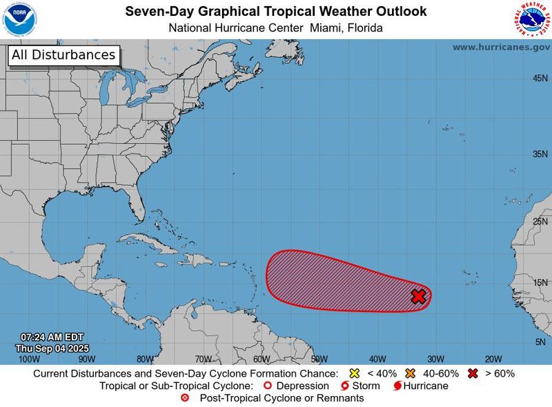
Is Invest 91L headed to the Texas coast?
In the Atlantic, the hurricane center is keeping tabs on Invest 91L over the central tropical Atlantic.
Forecasters said the wave continues to produce disorganized showers and thunderstorms, and that environmental conditions are conducive for gradual development of this system during the next several days.
The system is expected to move westward around 5 mph across the eastern and central tropical Atlantic into early next week, with forecasters giving the system an 90% chance of formation through the next seven days and 60% in the next two days.
Invest 91L spaghetti models
Texas weather watches and warnings
Stay informed. Get weather alerts via text
Brandi D. Addison covers weather across the United States as the Weather Connect Reporter for the USA TODAY Network. She can be reached at baddison@gannett.com.
This article originally appeared on El Paso Times: Lorena weakens to post-tropical cyclone. What to expect in Texas — see radar
Reporting by Brandi D. Addison, USA TODAY NETWORK / El Paso Times
USA TODAY Network via Reuters Connect