Hurricane Erin is moving away from the North Carolina coast and the United States, according to the latest advisory from the National Hurricane Center.
While Erin’s eye was well north of Florida Thursday morning, Aug. 21, conditions along the coast remain dangerous and beachgoers at most U.S. east coast beaches were cautioned against going in the water.

➤ Track all active storms
➤ Weather alerts via text: Sign up to get updates about current storms and weather events by location
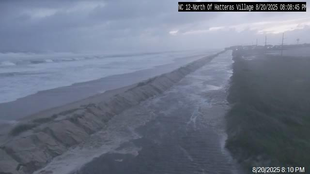
The National Weather Service in Morehead City, North Carolina, posted on X Wednesday night Highway 12 was completely submerged north of Hatteras Village.
At 5 p.m., Erin was located 370 miles east-northeast of Cape Hatteras, North Carolina, or 275 miles northwest of Bermuda.
Maximum sustained winds were 100 mph.
➤ Don’t have a hurricane supply kit? From the basics to the extras, here’s what you need
Where is Hurricane Erin going? See projected path
Special note on the NHC cone: The forecast track shows the most likely path of the center of the storm. It does not illustrate the full width of the storm or its impacts, and the center of the storm is likely to travel outside the cone up to 33% of the time.
Hurricane Erin spaghetti models
Special note about spaghetti models: Illustrations include an array of forecast tools and models, and not all are created equal. The hurricane center uses only the top four or five highest performing models to help make its forecasts.
➤ Track Hurricane Erin
➤ How often has Florida been impacted, threatened by August hurricanes? We took a look back
Hurricane Erin storm tracker, path
Satellite view of Hurricane Erin
Expected peak storm surge expected from Hurricane Erin
See coastal flood advisories, warnings and watches for Aug. 21
Track all active Atlantic storms and disturbances
What should you do now to prepare for hurricane season?
Officials regularly encourage Florida residents to prepare for storms before a hurricane is approaching while shelves are full stocked and you aren’t battling crowds all rushing to the store at the same time.
➤ Don’t have a hurricane supply kit? From the basics to the extras, here’s what you need
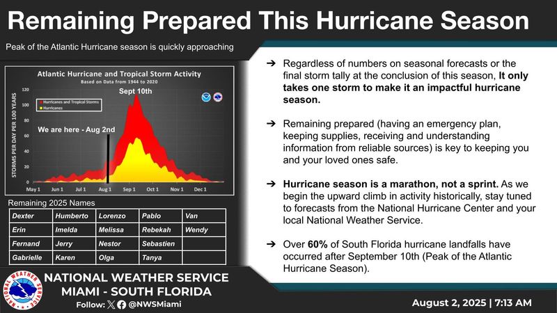
“It only takes one storm to make it an impactful year for your community,” the National Hurricane Center Miami posted on X. “Hurricane season is a marathon, not a sprint.”
On Aug. 1, specific hurricane supplies became permanently tax free in Florida, ranging from batteries to generators.
➤ See list of emergency supplies you can now buy tax free
Florida weather radar for Aug. 21, 2025
Weather watches and warnings issued in Florida
When is the Atlantic hurricane season?
The Atlantic hurricane season runs from June 1 through Nov. 30.
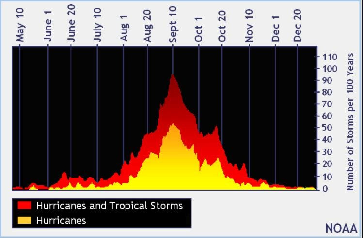
Ninety-seven percent of tropical cyclone activity occurs during this time period, NOAA said.
The Atlantic basin includes the northern Atlantic Ocean, Caribbean Sea and Gulf of America, as the Gulf of Mexico is now known in the U.S. per an order from President Trump. NOAA and the National Hurricane Center are now using Gulf of America on its maps and in its advisories.
When is the peak of hurricane season?
The peak of the season is Sept. 10, with the most activity happening between mid-August and mid-October, according to the Hurricane Center.
Hurricane names for 2025 season
Here are the names for the 2025 Atlantic hurricane season, along with how to pronounce them:
Stay informed. Get weather alerts via text
What’s next?
We will update our tropical weather coverage daily.
Download your local site’s app to ensure you’re always connected to the news. And look for our special subscription offers here.
This story has been updated to include new information.
This article originally appeared on Treasure Coast Newspapers: Hurricane Erin spaghetti models, tracker. Who is feeling impacts and where will it go next?
Reporting by Cheryl McCloud and Ashley Ferrer, USA TODAY NETWORK – Florida / Treasure Coast Newspapers
USA TODAY Network via Reuters Connect