After experiencing back-to-back heat advisories at the beginning of the week, the Florida Panhandle will get a couple of days to slightly cool off thanks to tropical downpours forecast through Saturday.
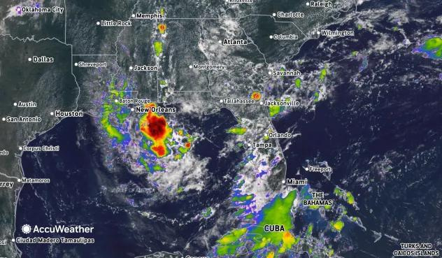
A broad area that AccuWeather is calling a “tropical rainstorm” is set to drench the Gulf Coast through the weekend and has already dropped just under a quarter-inch of rain in Pensacola on Wednesday.

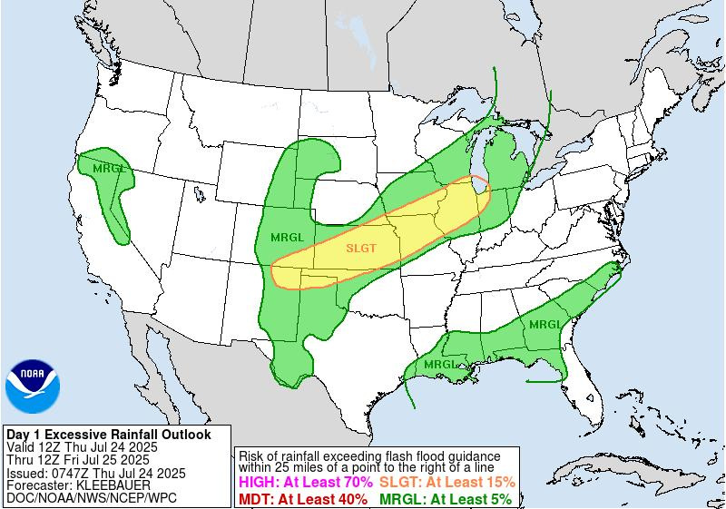
The National Hurricane Center, which is monitoring the disturbance, says the system has a low chance of tropical development over the next couple of days. The large system is still located over the north-central Gulf, but is likely to move inland by this weekend.
“If the bulk of the storm remains offshore and over the open waters of the Gulf, there will be a better chance of development than a low risk,” said AccuWeather Lead Hurricane Expert Alex DaSilva.
Moving inland would squash any chance of further development.
The Florida Panhandle isn’t out of the woods just yet. Pensacola through Panama City will see high chances of showers and thunderstorms through Saturday. Some areas could see as much as 0.75 inches of rain, according to the National Weather Service.
‘Tropical rainstorm’ will bring slightly cooler temperatures, plenty of rain to the Florida Panhandle
Pensacola got its first taste of what will be a stormy weekend on Wednesday, with widespread storms dropping approximately 0.24 inches of rain in the area, according to the National Oceanic and Atmospheric Administration’s NOWData.
The low-pressure area will bring more widespread showers and thunderstorms just south of the western Florida Panhandle and Alabama coasts Thursday morning. A moist southerly breeze will bring that stormy weather inland from the Gulf through early Saturday.
Those storms will hit the Pensacola area around 1 p.m. on Thursday, dropping between a tenth to a quarter-inch of rain. Some areas could see more if a thunderstorm pops up.
Friday is forecast to be the wettest day of the week. Pensacola will see some showers and a possible thunderstorm before things peak between 1 and 4 p.m. Rainfall totals are expected to be between a quarter and half of an inch.
Saturday will bring some showers, but the system should move past the Florida Panhandle by Saturday night.
Temperatures are forecast to drop as storms begin rolling into the area. The high temperature will hit near 87 degrees on Thursday before hovering around 90 degrees on Friday and Saturday, according to the latest NWS forecast.
Oppressive heat will hit the Pensacola area again next week, thanks to a massive heat dome that could linger into much of August, which is likely to trigger more heat advisories.
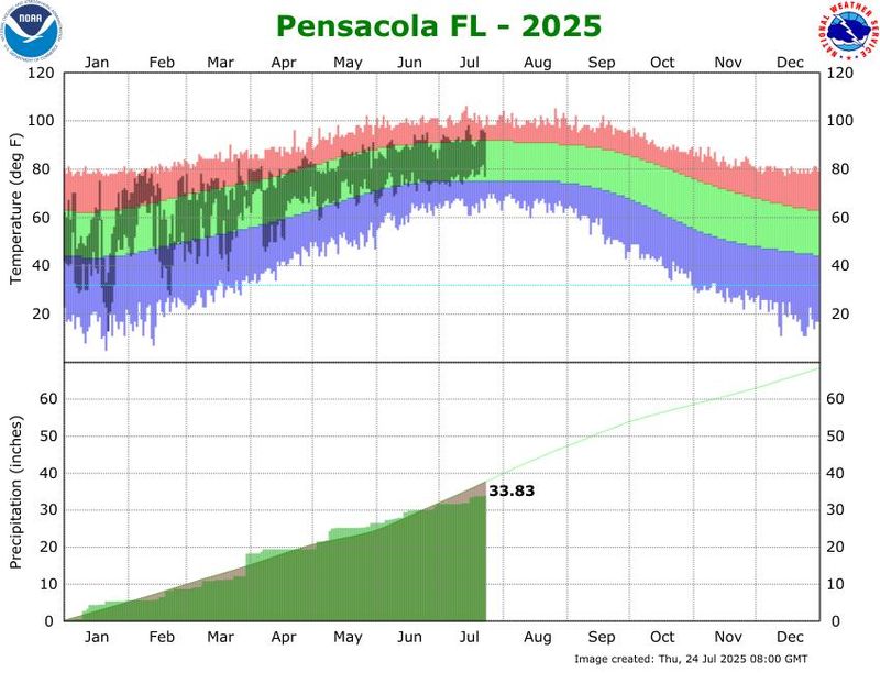
Pensacola’s July has been 1.3 degrees hotter than average
July has been a toasty one in Pensacola, with temperatures averaging 1.3 degrees hotter across the month so far, according to NOAA’s latest climate data. Temperatures were about 4.3 degrees hotter over the past three days, coinciding with the recent heat advisories.
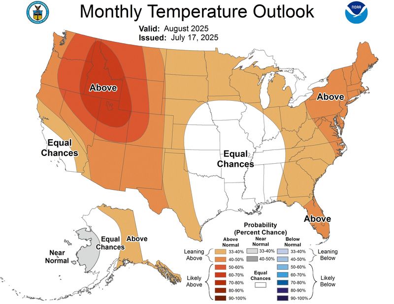
How hot will August be in Florida?
NOAA’s Climate Prediction Center believes that the majority of Florida is likely to see above-normal temperatures in August. The Pensacola area stands out as the only part of the state that has equal chances of seeing below- or above-normal temperatures.
The map of areas impacted by the current heat dome is a near inversion of NOAA’s monthly temperature map, which was issued on July 17. The odds could swing toward Pensacola seeing a warmer-than-normal August should the dome stick around.
National Hurricane Center tracks three tropical waves in the Atlantic
There is plenty of tropical activity happening throughout the Atlantic aside from the tropical disturbance sitting off the Florida coast. The National Hurricane Center is tracking three tropical waves in the eastern Atlantic, central Atlantic and another east of the Lesser Antilles.
Eastern Atlantic tropical wave:
Central Atlantic tropical wave:
Western Atlantic tropical wave (repositioned):
What are tropical waves and why do we track them?
The term “tropical wave” envisions a large physical wave of water making its way across the Atlantic or Caribbean. Menacingly, thanks to its association with tropical storms.
In actuality, tropical waves aren’t seen with our eyes. The term describes big ripples or waves within the atmosphere. What we can see are the clouds, rain and thunderstorms that tropical waves are known to produce.
The National Weather Service describes a tropical wave as an “elongated area of relatively low pressure moving east to west across the tropics,” which is also referred to as easterly waves.
A low-pressure area is another weather term that describes an area where the atmospheric pressure is lower than the surrounding air. Air rises in low-pressure areas, which leads to cloud formation and potential shower and thunderstorm activity. The rising air also creates wind as the air rushes to fill the space.
Low-pressure areas happen all over the place, but when they happen over the tropics, it’s worth monitoring because the pattern described above, combined with warm water, is what fuels hurricane development and intensification.
AccuWeather estimates that 85% of all tropical development can be traced back to tropical waves, making them important to track.
Pensacola weather radar
Heat index alert: Weather watches and warnings issued in Florida
This article originally appeared on Pensacola News Journal: ‘Tropical rainstorm’ will drench the Florida Panhandle and bring slightly cooler temps
Reporting by Brandon Girod, Pensacola News Journal / Pensacola News Journal
USA TODAY Network via Reuters Connect