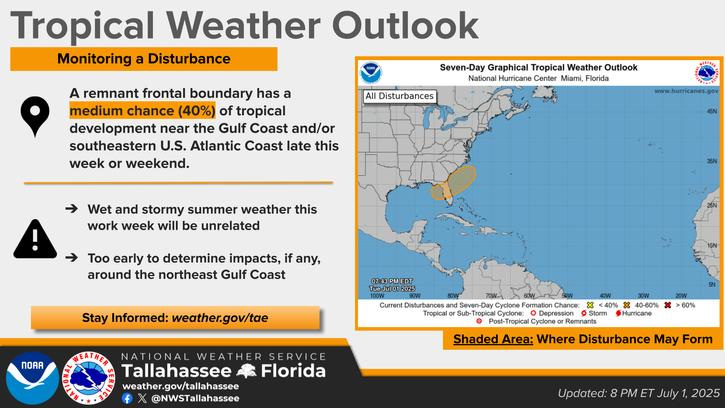
PANAMA CITY — The National Hurricane Center has upgraded the disturbance hovering over the state to a 40% chance of development over the next seven days. Here’s a look at the week ahead in weather and how this system could affect holiday plans.

The daily regime of high afternoon thunderstorm and rain chances could come to an end on July 3. Chances of precipitation fall to 20% and aren’t expected to pick up again until July 6, with a 40% chance of rain, according to the National Weather Service.
Brutal temperatures, however, are not expected to let up any time soon. The heat index on July 3 is expected to be over 100, and the heat on Independence Day is hovering around 98. AccuWeather predicts a feels-like temperature of 112 with an extreme UV index. After July 4, temperatures for the near future sit around the mid-90s.
Other than some oppressive heat, July 4 only has a 20% chance of thunderstorms after 2 p.m. On Saturday, July 5, rain chances pick up a bit at 30%. Sunday, July 6, might be the day some reconsider their outdoor plans, with a 40% chance of thunderstorms, although most of the day should be sunny and hot.
Looking ahead into next week, there’s a daily 40% chance of showers and thunderstorms and a slight dip in temperatures to the low 90s.
The system forming over the state isn’t expected to have immediate impacts. New graphics from NHC show the system stretching more northeastward on July 2. The agency says conditions are only marginally conducive for some slow development, although a tropical or subtropical depression could form over the weekend or early next week.
NHC says, regardless of development, heavy rains could impact swaths of the southeast, particularly around the west-central Florida coast.
Long-term forecasts haven’t changed from the Climate Prediction Center. The agency expects above-average temperatures and humidity into the near future for our area. Their Global Tropics Hazards Outlook shows a slow next few weeks in terms of hurricane development.
Yellow flags were flying over Panama City Beach on July 2, indicating a moderate surf and strong currents. There’s simultaneously a moderate rip current risk; swimmers should exercise caution.
This article originally appeared on The News Herald: What will the weather be like in Bay County on July 4 weekend as a system is brewing?
Reporting by Dylan Gentile, Panama City News Herald / The News Herald
USA TODAY Network via Reuters Connect