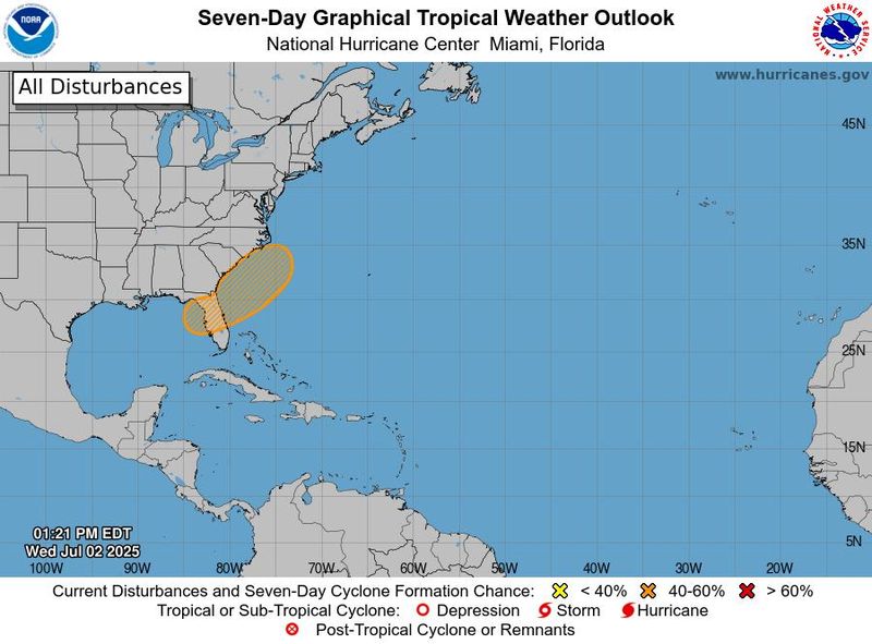
Chances for something tropical developing over or near Florida in the coming days increased while you slept.
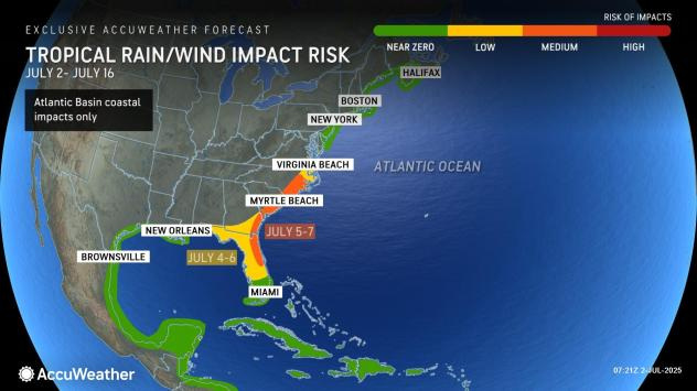
There’s a 40% chance for a tropical or subtropical depression forming over the next seven days if an area of low pressure develops in the southeastern Atlantic or Gulf by the holiday weekend, according to the National Hurricane Center.

➤ Track all active storms
➤ Weather alerts via text: Sign up to get updates about current storms and weather events by location
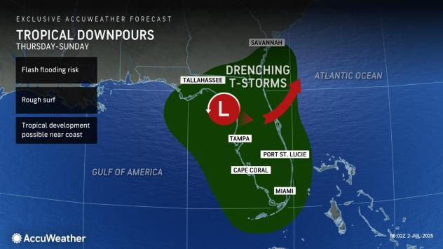
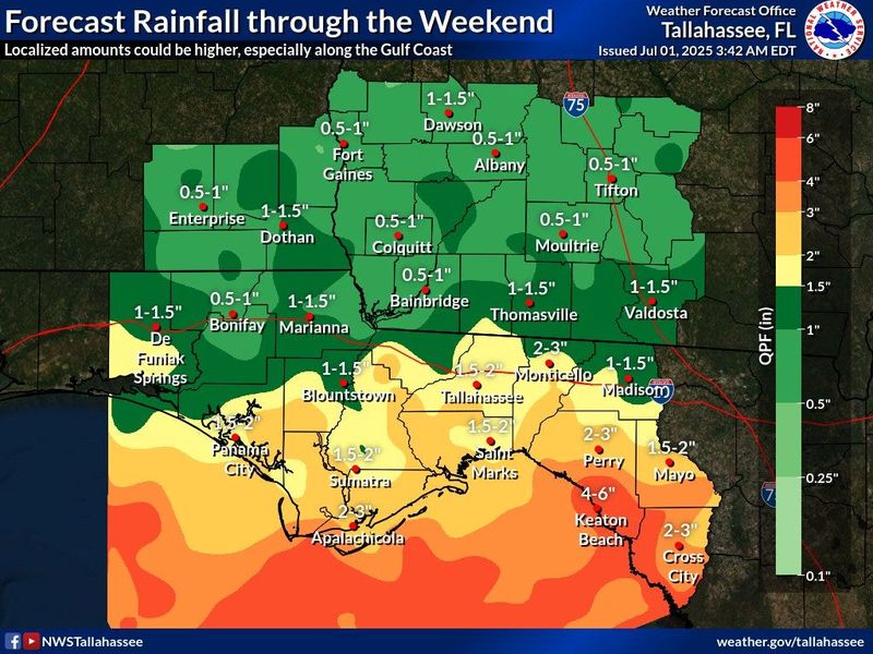
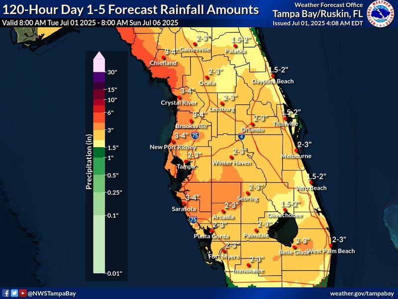
Regardless of development, the system could bring up to 6 inches of rain to some portions of Florida through the Fourth of July weekend, according to the National Weather Service.
The next named storm of the 2025 Atlantic hurricane season will be Chantal.
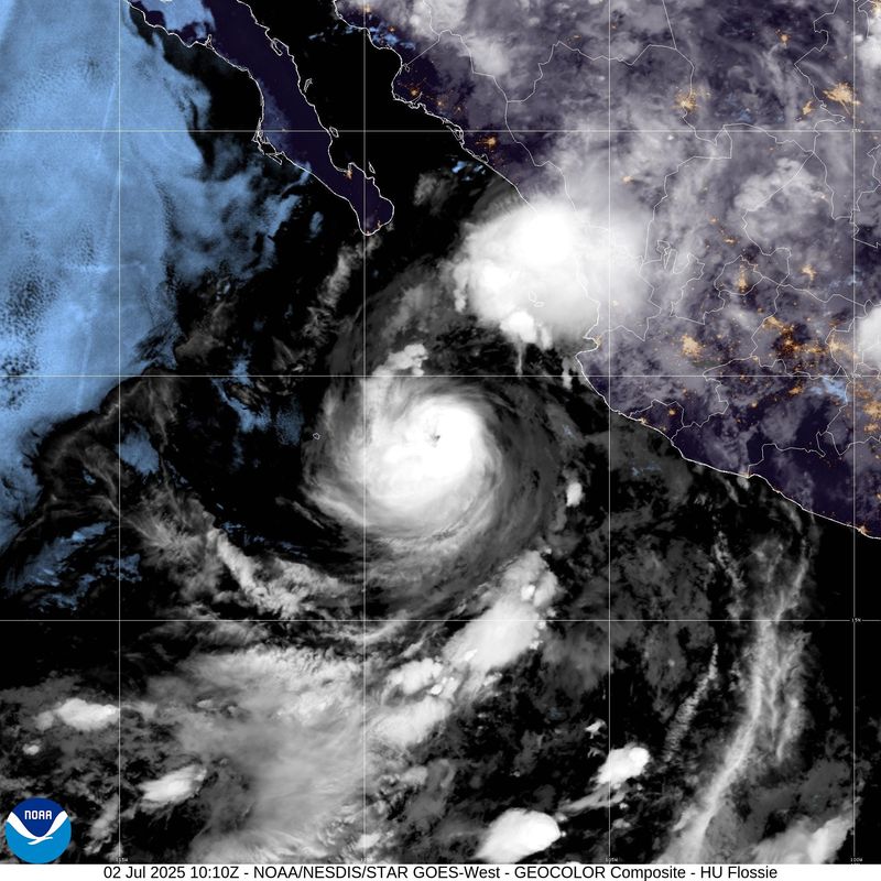
In the eastern Pacific, Hurricane Flossie — now a Category 3 storm with 115 mph winds — is moving west-northwest away from land. Weakening is expected by the end of the day, July2.
Here’s the latest advisory from the National Hurricane Center as of 2 p.m. July 2:
Is a tropical storm or hurricane coming toward Florida?
An area of low pressure could develop near the southeast U.S. Atlantic or Gulf coasts by this weekend along a weakening frontal boundary, according to the National Hurricane Center.
Environmental conditions appear only marginally conducive for some slow development, but a tropical or subtropical depression could form in this region over the weekend or early next week while the system drifts toward the north or northeast.
Regardless of development, heavy rainfall is possible across portions of the southeast U.S., particularly across the west-central Florida coast.
Could tropical system impact Florida over holiday weekend?
“Regardless of development, heavy rainfall is possible across portions of the southeast U.S., particularly across West-Central Florida,” the Florida Department of Emergency Management said.
“Those heading to the beaches for the holiday weekend from northern Florida and the Alabama and Mississippi panhandles to the Carolinas are urged to monitor the forecast, as there may be rough surf and rip currents and perhaps gusty winds should a tropical depression or storm develop,” said Alex DaSilva, AccuWeather lead hurricane expert, adding, “We feel the development window is from around July 4 to early next week.”
Factors helping prevent tropical development include wind shear and dry air, including Saharan dust moving across the Atlantic and into the Gulf.
Where is Hurricane Flossie?
Hurricane Flossie is about 315 miles south-southeast of Cabo San Lucas, Mexico.
Maximum sustained winds are near 115 mph, with higher gusts. Flossie is a Category 3 hurricane on the Saffir-Simpson Hurricane Wind Scale.
Little change in strength is forecast this morning, with rapid weakening expected to begin by the end of the day.
All coastal watches and warnings have been discontinued.
Hurricane Flossie spaghetti models
This forecast track shows the most likely path of the center of the storm. It does not illustrate the full width of the storm or its impacts, and the center of the storm is likely to travel outside the cone up to 33% of the time.
Hurricane Flossie tracker, path
This forecast track shows the most likely path of the center of the storm. It does not illustrate the full width of the storm or its impacts, and the center of the storm is likely to travel outside the cone up to 33% of the time.
What do the colored, hatched areas on the NOAA map mean?
The hatched areas on the National Hurricane Center’s tropical outlook map indicate “areas where a tropical cyclone — which could be a tropical depression, tropical storm or hurricane — could develop,” said National Hurricane Center Deputy Director Jamie Rhome.
The colors make it visibly clear how likely a system could develop, with yellow being low, orange medium, and red high.
The National Hurricane Center generally doesn’t issue tropical advisories until there is a named storm, but there is an exception.
“If a system is near land and there is potential for development, the National Hurricane Center won’t wait before it issues advisories, even if the system hasn’t become an actual storm. This gives residents time to prepare,” Rhome said.
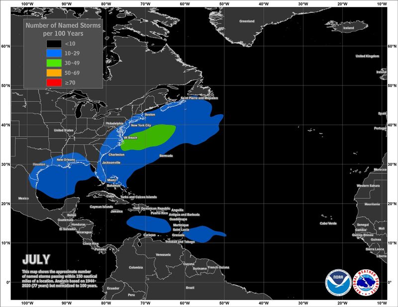
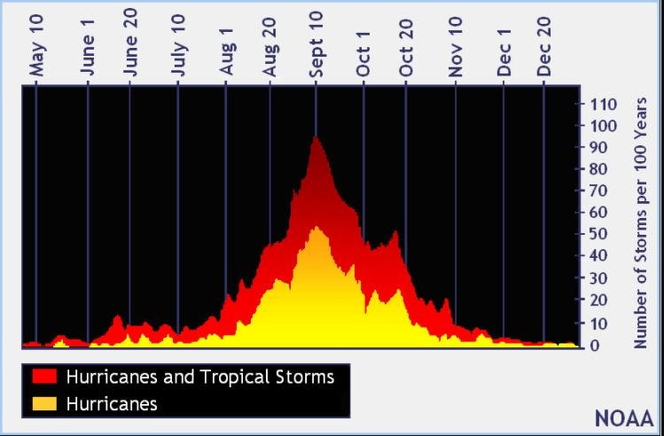
Tropical development common close to Florida in July
Named storms historically develop close to the U.S. in July, especially in the Gulf and off the Atlantic coast between Florida and the Carolinas.
Later in the season, tropical storms and hurricanes develop out of tropical waves moving off the coast of Africa.
NOAA tracking 5 tropical waves, including 2 in Caribbean
Elsewhere in the tropics, the National Hurricane Center is monitoring five tropical waves, including two in the Caribbean:
Florida weather radar for July 2, 2025
Florida weather forecast for July 2, 2025
Florida weather forecast for July 2, 2025
Weather watches and warnings issued in Florida
When is the Atlantic hurricane season?
The Atlantic hurricane season runs from June 1 through Nov. 30.
Ninety-seven percent of tropical cyclone activity occurs during this time period, NOAA said.
The Atlantic basin includes the northern Atlantic Ocean, Caribbean Sea and Gulf of America, as the Gulf of Mexico is now known in the U.S. per an order from President Trump. NOAA and the National Hurricane Center are now using Gulf of America on its maps and in its advisories.
When is the peak of hurricane season?
The peak of the season is Sept. 10, with the most activity happening between mid-August and mid-October, according to the Hurricane Center.
National Hurricane Center map: See what forecasters watching now
Systems currently being monitored by the National Hurricane Center include:
Why does NHC say ‘tropical cyclone’ on its maps instead of hurricane or tropical storm?
Tropical cyclone is the generic term used by the National Weather Service, NOAA and the National Hurricane Center for any tropical system, even if it’s in the tropical Atlantic basin.
To be more precise, a tropical cyclone is a “rotating, organized system of clouds and thunderstorms that originates over tropical or subtropical waters and has closed, low-level circulation,” NOAA sadi.
Once maximum sustained winds reach 74 mph, what it is called is determined by where it originated:
Interactive map: Hurricanes, tropical storms that have passed near your city
Stay informed. Get weather alerts via text
What’s next?
We will update our tropical weather coverage daily.
Download your local site’s app to ensure you’re always connected to the news. And look for our special subscription offers here.
This story was updated to add new information.
This article originally appeared on Naples Daily News: Chances increase slightly for tropical development over Fourth of July. See Florida impact
Reporting by Cheryl McCloud, USA TODAY NETWORK – Florida / Naples Daily News
USA TODAY Network via Reuters Connect