Showers and thunderstorms associated with Invest 94L continue to show signs of organization, Sept. 26.
The National Hurricane Center said a tropical depression is expected to form as the system moves near the Bahamas later today, Friday, Sept. 26, or over the weekend.

➤ Track Invest 94L
➤ Weather alerts via text: Sign up to get updates about current storms and weather events by location
If it continues to strengthen, it will become Tropical Storm Imelda.
Interaction with Hurricane Humberto to the east of Invest 94L is making track and intensity difficult for forecasters in what’s known as the Fujiwhara effect.
What is more certain is that indirect impacts to Florida and the southeast coast over next several days are increasing and could include wind, rain and storm surge, according to the Hurricane Center.
Here’s what to know about Invest 94L and its possible impact on Florida.
Storm tracker: What is Invest 94L path?
This automated graphic shows a map of all active storms in the Atlantic basin.
Can’t see the graphic? Open in a new browser.
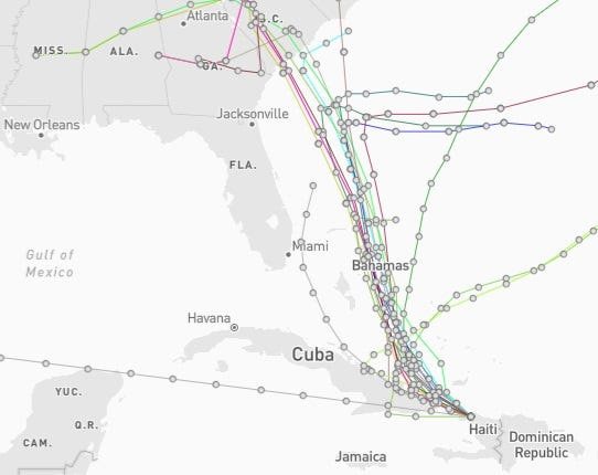
Invest 94L 2025 spaghetti models
Special note about spaghetti models: Spaghetti model illustrations include an array of forecast tools and models, and not all are created equal. The Hurricane Center uses only the top four or five highest performing models to help make its forecasts.
Will Invest 94L impact Florida?
That’s unclear at this time because interaction between the invest and Hurricane Humberto — known as the Fujiwhara effect — is making forecasts difficult.
“While there is significant uncertainty in the long-range track and intensity of the system, the chances of wind, rainfall, and storm surge impacts for a portion of the southeast U.S. coast during the next several days are increasing,” the Hurricane Center said.
“At this time, we are thinking that the storm should remain off the east coast of Florida, regardless of the scenario with Humberto,” said AccuWeather lead hurricane expert Alex DaSilva at 8 a.m. Sept. 26.
“So, right at this point, we do not expect a direct landfall to Florida, although it’s possible that this could get pretty close. Florida still needs to pay close attention.”
Once the invest develops a defined area of circulation, forecasters will have a better idea of what will happen.
Until then, “all possibilities are still on the table,” DaSilva said, “but right now, we still do expect a path to the east of Florida, regardless of what happens with Humberto. So there still could be some rain that gets into Florida, although we don’t expect significant impacts at this point.”
Weather radar shows conditions across Florida
Current weather watches and warnings issued in Florida
As of Friday morning Sept. 26, no watches or warnings associated with Invest 94L have been issued in Florida or the U.S.
Excessive rainfall forecast across Florida
Are you prepared for a storm? What do you need in hurricane kit?
Officials regularly encourage Florida residents to prepare for storms before a hurricane is approaching, while shelves are fully stocked.
On Aug. 1, specific hurricane supplies became permanently tax-free in Florida, ranging from batteries to generators.
➤ Don’t have a hurricane supply kit? From the basics to the extras, here’s what you need
Here are some of the basics you should have:
Stay informed. Get weather alerts via text
Download your local news app to ensure you’re always connected. And look for our special subscription offers here.
What’s next?
We will update our tropical weather coverage daily.
Download your local site’s app to ensure you’re always connected to the news. And look for our special subscription offers here.
This story has been updated to include new information.
This article originally appeared on Fort Myers News-Press: Spaghetti models for Invest 94L. What can Florida expect from what may become Imelda?
Reporting by Cheryl McCloud, USA TODAY NETWORK – Florida / Fort Myers News-Press
USA TODAY Network via Reuters Connect