
By Jim Bloch

You can swim, kayak, canoe, motorboat or even drive within eyesight of six landmarks — sometimes watermarks — that help tell the history of the St. Clair Flats, the largest fresh water delta in the world, over the past 250 years. The story starts with indigenous residents of the area before European contact in the mid 1650s and continues all the way to the rise of the great passenger steamers like the Tashmoo and the resorts on Harsens Island in the early 20th Century.
The delta fans out at the base of the 39-mile long St. Clair River, where the river feeds into Lake St. Clair through the mouths of seven main channels and dozens of smaller ones winding around 11 major islands and innumerable mini-islands.

The South Channel lighthouse southeast of Harsens Island.
The state of Michigan lies on the west shore of the river, the province Ontario on the east. Together, the St. Clair River, Lake St. Clair and the Detroit River form the great connecting artery between Lake Huron and Lake Erie.
Daniel F. Harrison, a maritime archeologist and retired academic librarian, tells the history of the Flats in “A Cascade of Contingencies: Disruption and Innovation in the St. Clair Flats, 1679-1860,” an article in the Michigan Historical Review, Volume 49, No. 2, Fall 2023.
Six historical ‘markers’
Harrison points to six historical markers of various kinds that signify the history of the Flats. Some of the markers are natural features of the Flats; others are manmade: A) Walpole Island; B) the ribbon farms north of Algonac on the Michigan mainland; C) the Elbow in the North Channel of the St. Clair River where it flows into Anchor Bay; D) the Old South Channel Lights; E) the St. Clair Ship Canal and the Cutoff; and F) Tashmoo Park on Harsens Island.
The sites form an approximate circle “where the march of history goes counterclockwise, physically and chronologically,” says Harrison.
The Flats: From boon to bottleneck
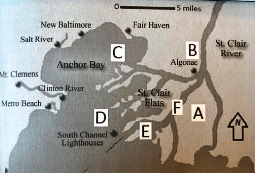
A map of northern Lake St. Clair and the Flats.
With their copious sandbars, winding and narrow channels, unpredictable currents, the St. Clair Flats presented unique opportunities and challenges to mariners. The native Indian mastered them with birch bark canoes. Beginning in 1769, the French explorers, missionaries, fur traders and settlers followed the lead of the natives, using canoes and similar vessels to follow established routes through the delta, including making use of critical portages.
But once the British took control of the lakes with its larger sloops and schooners beginning in 1863, the Flats became a navigation bottleneck between the lower and upper Great Lakes.
(A) Walpole Island
“Walpole Island preserves habitat for native flora and fauna, and an ancestral homeland for the indigenous people who have coexisted with them for centuries,” Harrison writes. On the island, “First Nations maintain their Anishinaabeg identity through traditions, rituals, language, hunting and fishing, and arts and crafts — including boatbuilding.”
(B) Ribbon farms
“Just north of Algonac, surviving ribbon farm parcels epitomize the colonial French relationship between land, water, people and resources,” says Harrison.
In addition to fashioning canoes, the French settlers adapted their flat-bottomed bateaux to local uses.
“These vessels perfectly complemented the distinctive French colonial settlement pattern of ‘ribbon farms,’ narrow parcels fronting on a navigable but unimproved waterway,” Harrison says.
Overall, the French lived “lightly” on the land.
(C) Elbow
“At the Elbow, the keel-marks of British ships may finally be gone from the hard clay, but the unmodified natural channel remains a reminder of their determination to master a unforgiving obstacle,” says Harrison. “At least its buoys are now in the right places — ignore them at your peril.”
After the French and Indian War, the British became the dominant power in North America. Maritime trade tended to move from Detroit east to Niagara and north from St. Clair to Michilimackinac.
“The schooner Gladwin … under the command of Captain Patrick Sinclair, provided regular service to Michilimackinac from its home port at Fort Sinclair (now St. Clair, MI),” writes Harrison. “The intervening delta created a gap between Detroit and Fort Sinclair not easily traversed by ship.”
Schooners had to be unloaded at the Flats and their loads ferried by canoe or bateaux from one side of the Delta to the other. At first, the South Channel provided the main route despite the bar at its mouth. By 1800, commercial travel shifted to the North Channel, in part because of the shelter offered by Anchor Bay from storms out of the north and east while waiting to unload and transport their cargo through the hazardous channel. In time, businesses grew up along the shore to assist the movement of ships and goods through the Flats.
Canal craze underlines choke point
Britain’s canal building craze of the late 1700s migrated to the U.S. in the form of the Erie Canal, which opened in 1825 and the Welland Canal, which opened in 1829. Both functioned to eliminate Niagara Falls and its escarpment as a barrier to shipping from the Atlantic Ocean into the Great Lakes. Now the only serious blockage from the East Coast to Chicago and the Mississippi River was the St. Clair Flats.
Three things had to happen to streamline passage for the new steamships through the delta: Accurate surveying; accurate channel marking; and the removal of impediments at the mouth of the channels. The Army Corps of Engineers solved the first problem in 1838 and a Congressional lighthouse bill in 1848 helped solve the second, with the establishment of the buoy system. Open water dredging remained technically impossible until 1848.
Ultimately, shipping companies and federal engineers picked the South Channel for dredging because it cut five miles off the length of the passage through the Flats.
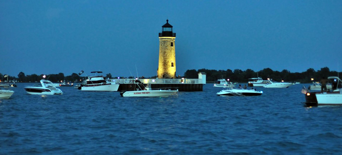
(D) Old South Channel Lights
“The Old South Channel Lights epitomize the Yankee ingenuity that surveyed the natural channel, marked it and made the best of it during the national paroxysm of the Civil War,” says Harrison.
The lights consist of the Beacon Light and its companion lighthouse, completed in 1859, which guided captains to the dredged channel. No further work took place until the end of the war. The lights, still in use today, are now automated.
(E) Ship Canal and the Cutoff
“The broad artificial channels of the St. Clair Ship Canal and the Cutoff are the products of the industrial might of the United States and Canada, creating one of the world’s busiest commercial waterways,” Harrison writes.
The ship canal opened in 1871, cutting off the original entrance into the South Channel.
“Progressively widened and deepened over the following century, it was superseded in 1962 by the St. Clair Cutoff, providing a straightened passage from Algonac to the open waters of Lake St. Clair.”
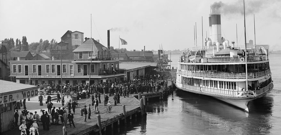
(F) Tashmoo Park
Tashmoo Park on Harsens Island’s eastern flank “represents the waterside resorts and tourist hotels that sprang up during the halcyon decades surround the turn of the twentieth century,” Harrison says. “Then known as ‘Michigan’s Venice,’ the Flats became Detroit’s favorite getaway for both socialites and the emerging industrial proletariat, its waters plied by private yachts and elegant ‘palace steamers’ like the legendary Tashmoo.”
Jim Bloch is a freelance writer based in St. Clair, Michigan. Contact him at bloch.jim@gmail.com.