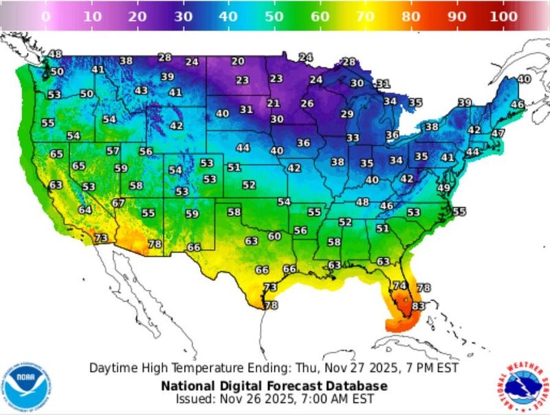
A chill leaking out of Canada is swallowing much of the gut of the country with a bead on the Northeast but South Florida will remain steadfastly warm, at a seasonable sizzle, with likely the hottest temperatures in the country on Thanksgiving Day.
The cold with potentially feet of lake effect snow smothering parts of the Midwest and lifting toward New England will swipe at Florida’s Panhandle dropping overnight temperatures into the 30s and 40s ahead of the weekend before bouncing back with lows in the 50s and mostly clear skies on Saturday.

But because the chugging storm system, with another on its heels, is moving more easterly — horizontal to the subtropical latitudes — South Florida won’t get that firehose of frigid air like earlier in November where a shot of cold blasted directly south down the Peninsula
The Nov. 11 overnight temperature in West Palm Beach plummeted to 45 degrees. That’s 22 degrees below normal.
But the coolest Palm Beach International Airport is expected to experience over the next several days is 65 degrees early on Nov. 29.
“You will see some changes in South Florida Friday and Saturday when it will get somewhat cooler,” said AccuWeather senior meteorologist Dan Pydynowski. “Humidity will drop, people will notice. By Sunday, you’re back into the 80s.”
The cool front is forecast to move through the state on Thanksgiving Day when sunny skies and a high in the lower 60s are forecast in areas of the Panhandle. Temperatures in the low 80s and a 40% chance of showers are forecast in West Palm Beach.
Normal daytime highs in late November in Tallahassee are 69 degrees. In South Florida, they are closer to 78 to 79 degrees, which is near what is forecast.
Richard Bann, a meteorologist with the National Weather Service’s Weather Prediction Center, said the only area of the country that may challenge South Florida’s warm temperatures on Thanksgiving and over the weekend would be the far southern reaches of Texas.
Brownsville, Texas is forecast to have a high temperature of between 71 and 78 degrees on Thanksgiving, increasing to 74 to 79 on Nov. 28.
“This whole air mass isn’t going to have the prolonged fetch of really cool air that will make it the dominant feature,” Bann said. “It’s going to cool down but not like we’ve seen in these really cold blasts.”
The Storm Prediction Center has South Florida as the only area in the country with the potential for thunderstorms on Thanksgiving. Churned up by the cool front, the air could get moist enough and rise fast enough during daytime heating for the random clap of thunder to be heard, but no severe storms are in the forecast through the weekend.
“This is not a situation where there’s a massive squall line moving through,” Pydynowski said.
Showers would likely be welcome statewide.
Rain on Thanksgiving would be helpful for parched Florida
One month out of the wet season when the state should be well satiated from summer rain, more than 60% of the state is experiencing some level of drought. Areas of the Panhandle are in “extreme” to “exceptional” drought, which are the highest two levels on the U.S. Drought Monitor scale.
Palm Beach County’s western boundaries and around Lake Okeechobee are in moderate drought with much of the central region, about 50% of the county, considered abnormally dry.
Florida climatologist David Zierden said the exceptional drought in the Panhandle is the first registered since 2012 in Florida.
He attributed the dryness to the recurving tropical cyclones this hurricane season that avoided U.S. landfalls.
“Result … the onset of extreme drought in the Southeast,” Zierden said in a social media post.
Post-Thanksgiving travelers should watch for a storm expected to begin bubbling Friday that will start in the northern Plains and then drag east to Chicago and Michigan and Ohio, with showers and thunderstorms hitting Texas and the lower Mississippi Valley.
In South Florida, the National Weather Service is warning of sustained winds of 20 to 25 mph with gusts to 30 mph through the weekend. Wave heights in Atlantic coastal waters could reach 8 feet with up to 6 feet in the Gulf. There is also a high risk of rip currents along Atlantic beaches through at least Nov. 30.
“It’s not going to be a very fun time to be boating for the holiday weekend,” said Miami-based NWS meteorologist Robert Garcia. “Not great swim days for the Atlantic either.
Kimberly Miller is a journalist for The Palm Beach Post, part of the USA Today Network of Florida. She covers real estate, weather, and the environment. Subscribe to The Dirt for a weekly real estate roundup. If you have news tips, please send them to kmiller@pbpost.com. Help support our local journalism, subscribe today.
This article originally appeared on Palm Beach Post: Thanksgiving weather: A chill leaking from Canada. Will it reach us?
Reporting by Kimberly Miller, Palm Beach Post / Palm Beach Post
USA TODAY Network via Reuters Connect