Reality: in 2025, it was not very realistic.
In a year when AI images of ALF dunking a basketball through Saturn’s rings overtook podcasts rating hot sauce as the most valuable economic sector, perhaps it was inevitable that the weather would follow the bots, the stock market, and the rest of us into post-reality fever dreams.

And, indeed, this was a downright strange hurricane season, perhaps one of the most unusual on record.
Yet somehow, amidst the barrage of exploding Cybertrucks and diseased monkey escapes, the most impactful storm of 2025 on the Gulf and Southeast Coasts was not a hurricane, but a literal blizzard. In fact, this hurricane season had less U.S. landfall activity than 98% of the last 125 years. That’s weather I wouldn’t modify, even if illegal weather modification in Florida wasn’t now punishable by a $100,000 fine.
It was far from a quiet season, however, as 2025 saw three Category 5 hurricanes and more hurricane energy than two out of three years since 1950.
If there is no additional activity to come, that will be — I am not making this up — a 67th percentile performance. (I will pause so readers under 15 can scream 6-7 for several minutes.) Thankfully, like detailed plans for bombing Houthi rebels, 10 of this year’s 13 named storms were sent directly to the Atlantic. While the continental U.S. escaped, reality bit in the Caribbean, where merciless Melissa ravaged Jamaica and the vicinity.
Let’s take a look back on the dizzying highs and soporific lulls of the bizarre 2025 hurricane season, a year that defied logic, convention, and, sometimes, convection.
June and July: Chantal becomes the only tropical trouble inflicted on the U.S.
June got off to a languid start in the Tropics, with disorganized Andrea in the central subtropical Atlantic establishing the season’s mode on the 23rd. Barry became the only named storm to move through the Gulf of [Neutrality Disputed] this year on the 29th and 30th, causing excessive rainfall in east-central Mexico and indirectly contributing to devastating floods in Texas the following week.
On July 5th, Chantal made the sole U.S. tropical storm landfall of 2025 near Myrtle Beach. Rain totals of 10” or more caused about $500 million in flood damage in the Carolinas, even as Coldplay caused over $500 million in damage to one tech bro’s divorce settlement.
August: Hurricane Erin becomes the first Category 5 with a glancing blow to East Coast
Following a four-week siesta in activity, Tropical Storm Dexter proved less than sinister in early August as it crossed the open ocean, as did unremarkable Fernand later in the month.
Mid-month, all eyes were on Hurricane Erin, which skirted north of the Lesser Antilles and became the season’s first Category 5 on August 16th. Erin’s sustained winds dropped but its circulation expanded dramatically as it curled offshore between Bermuda and the Outer Banks on the 20th and 21st, resulting in modestly damaging storm surge in the mid-Atlantic and coastal New England, but no major U.S. impacts.
In other August news, AI became sentient and launched a surprise attack on humanity’s most cherished symbol: the Cracker Barrel logo. Markets soared by trillions as ChatGPT later agreed to return the Barrelman in exchange for not having to write any more papers on color symbolism in the “Great Gatsby,” plus control of Greenland.
September: Humberto and Imelda’s hurricane waltz spares the United States
Climatologically, about 35% of total storm activity in hurricane season takes place between August 27th and September 17th. This year, that number was zero percent.
For much of September, unusually dry and stable air prevented any storm activity in the Tropical Atlantic during the three peak weeks of the season, a feat managed just once in the prior 75 years.
However, like the humble penny, this calm ended abruptly.
Gabrielle reached Category 4 strength on the 22nd as it traced a familiar, harmless path into the central Atlantic. At month’s end, Hurricanes Humberto and Imelda met like generals, locking into a cosmic ballet that improbably prevented a U.S. hurricane landfall.
As Category 5 Humberto menaced Bermuda, its influence yanked Hurricane Imelda east from the Bahamas, while Florida’s East Coast was brushed by outer bands. The 450 miles between Humberto and Imelda were the least separating two hurricanes since at least the ‘60s, and resulted in satellite images that looked AI-generated other than the lack of six- or seven-fingered hands.
Obviously, markets soared.
October and November: Hurricane Melissa shows shatters records as a tropical terror
My initial plan for this season-in-review was to write it in the form of a song parody called, “It’s the End of the World as We Know It (But Hurricane Season Was Fine).” And for the first 149 days of hurricane season, including the forgettable maritime journeys of Jerry, Karen (unrelated to Phillies Karen), and Lorenzo, that seemed like a solid concept.
Unfortunately, day 150 wasn’t fine.
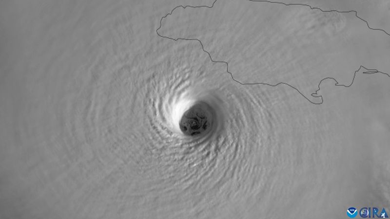
It was a brutal and singular day in Atlantic hurricane history, as Hurricane Melissa took its place at the furious limits of the hell a tropical cyclone can unleash on land.
Melissa, which formed on the 21st, moved at a glacial pace and gathered strength over the unnaturally warm and deep waters of the central Caribbean for nearly a week.
Melissa hit Category 5 strength on the 27th, and eschewing the eyewall replacement cycles typical of extremely intense hurricanes, continued intensifying until landfall in western Jamaica on the 28th. A diminished Melissa crossed eastern Cuba and the Bahamas on the 29th and raced past Bermuda on the 30th.
In its wake, Melissa left Hurricane Hunters limping back to base and the Atlantic record books provisionally rewritten.
Its estimated sustained winds (185 mph) and minimum pressure (892 millibars) are both exactly tied with the 1935 Labor Day Hurricane as the most severe of any landfalling Atlantic hurricane in history, and also ties for third-lowest pressure ever recorded in the Atlantic.
Melissa’s estimated sustained winds of 185 mph trail only 1980’s Allen, but that may be revised higher this spring when the NHC issues their final report on the hurricane.
Given that a Hurricane Hunter windsonde recorded a spacetime-warping 252 mph gust just 250 meters above the surface, a world record, I would not be surprised to see the NHC bump Melissa up to 190+ mph peak sustained winds when those much-discussed 2025 Best Track files are finally released. Stay tuned.
Is this real life?: How the 2025 hurricane season defied forecasts
Like international tourists or an interstellar comet, hurricanes wanted no part of the U.S. this year. (Incidentally, the fact that Comet 3I/ATLAS is currently speeding away from the solar system at 150,000 mph is the strongest possible evidence that it is controlled by intelligent life.)
While it was a great relief to scramble for Costco gold bars rather than Kirkland water and toilet paper in 2025, the total lack of threats after nine consecutive years with a Gulf Coast major hurricane landfall felt like a long walk through an uncanny valley.
Not to look a gift horse in the mouth, but what happened? Two main things: first, a favorable steering pattern, and second, a uncharacteristic dollop of luck.
As I mentioned, this wasn’t a quiet hurricane season. In July, WeatherTiger’s seasonal outlook called for a relatively quiet first half of the season, a furious second half, and around 135 total Accumulated Cyclone Energy units. That all basically happened, and we finished at 133 ACE, a bit above normal.
However, that activity was unusually concentrated into just a few monster storms, with Erin, Gabrielle, Humberto, and Melissa accounting for 85% of the season’s storm energy.
An unprecedented 60% percent of this season’s five hurricanes reached Category 5 status, with only 2005 recording more Cat 5s. AI slop is clogging the arteries of society, but in the Tropical Atlantic, 2025 was a year of quality over quantity.
That concentration is a double-edged sword, raising the prospect of cataclysmic landfalls like Melissa while at the same time meaning fewer bullets to dodge. Dodge (and DOGE) we certainly did this year: starting around Erin’s attempted approach in mid-August, the jet stream pattern generated persistent troughing and cutoff lows over the southeastern United States.
Those features brought a mild, dry fall to Florida and steered our hurricane allotment towards Bermuda. In fact, 2025 had the lowest percentage of total Atlantic activity occur near or over the continental U.S. since 1900, a measly 0.2% versus a typical 3 to 4%.
And when the steering pattern failed, luck kicked in. It’s not normal for a possible U.S. hurricane landfall to be stopped in its tracks by a different Category 5 hurricane, but that happened in 2025. I wouldn’t count on that particular deus ex machina saving us again in the future.
But we’ll take it, because like Newark air traffic control, I think we all felt a little out of touch in 2025. It’s hard to grapple with a world in which Chuck E. Cheese is a felon, a tough cheesecake tariff protects domestic cheesecake factories, and dueling is re-legalized (not sure about that one, I kind of checked out).
As our phones constantly told us, scam was likely. We’ll take wins where we can find them in this year of unrealistic alleged reality, and a benign U.S. hurricane season gave us a big one. I hope my storm coverage meant one less thing to worry about as you whitened your dueling gloves.
One final scrap of good news: I’ll be back in March with my first look at the 2026 hurricane season, and while things may certainly change over the winter, as of now I’m not expecting a busy year ahead.
Keep it real, Weather Fans, and as always, keep watching the skies.
Dr. Ryan Truchelut is chief meteorologist at WeatherTiger, a Tallahassee company providing forensic meteorology expert witness services and agricultural and hurricane forecasting subscriptions. Visit weathertiger.com to learn more. Email Truchelut at ryan@weathertiger.com.
This article originally appeared on Tallahassee Democrat: Cat. 5 chaos and a little luck: A hurricane season that broke reality
Reporting by Ryan Truchelut, WeatherTiger / Tallahassee Democrat
USA TODAY Network via Reuters Connect