A hurricane. A tropical storm. An invest expected to strengthen into a tropical depression soon.
That’s the quick look at what’s happening in the tropics Thursday, Sept. 25.

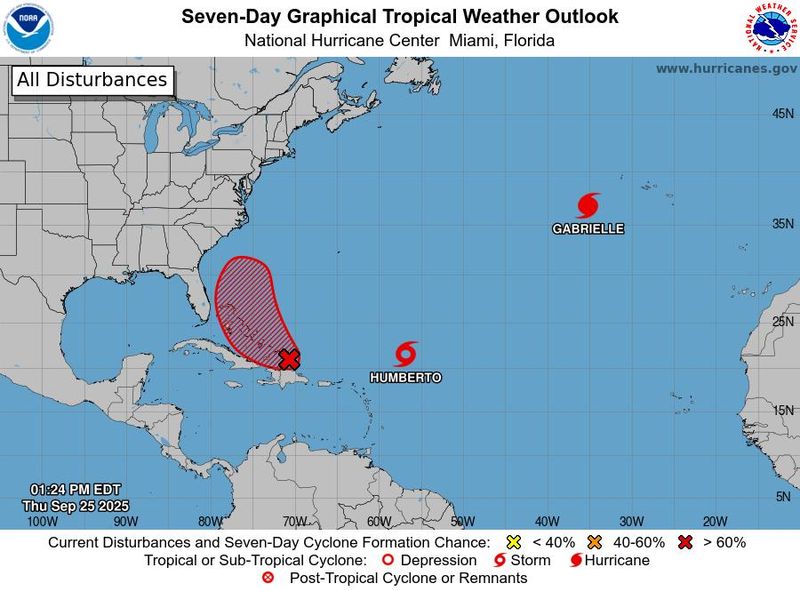
Hurricane Gabrielle continues to head east toward Portugal and Spain.
Tropical Storm Humberto is expected to become a hurricane in a day or so and a major hurricane over the weekend, with the latest models trending farther south and west.
➤ Track all active storms
➤ Weather alerts via text: Sign up to get updates about current storms and weather events by location
It’s the first time during the 2025 Atlantic hurricane season there have been two named storms simultaneously.
Closer to the United States and Florida is Invest 94L, which is expected to become a tropical depression within a couple of days, according to the National Hurricane Center.
“While there is significant uncertainty in the long-range track and intensity of the system, the chances of wind, rainfall, and storm surge impacts for a portion of the southeast U.S. coast are increasing,” the National Hurricane Center said.
What impacts Humberto and Invest 94L will have on the U.S. and Florida is difficult to predict since the two could interact with each other in what’s known as the Fujiwhara effect.
So far, there have been two hurricanes this season, Erin and Gabrielle. Both rapidly intensified into major hurricanes.
The next named storm for the 2025 hurricane season will be Imelda.
Here’s what you should know.
Where is Hurricane Gabrielle?
Hurricane Gabrielle is in the central Atlantic and moving fast — at 32 mph — toward the Azores, where a hurricane warning is in effect, according to the latest advisory from the National Hurricane Center.
Gabrielle is forecast to be at hurricane strength when it passes through the Azores west of Portugal today, Sept. 25, and into Friday.
Gabrielle is expected to bring hurricane conditions, dangerous storm surge and large destructive waves to the Azores.
Gabrielle may be far from the U.S. but indirect impacts from the hurricane continue to be felt. Swells generated by Gabrielle will continue to affect Bermuda, the northeastern coast of the U.S., and Atlantic Canada today. These swells are likely to cause life-threatening surf and rip current conditions, the Hurricane Center said.
Where is Tropical Storm Humberto?
Tropical Storm Humberto is expected to become a hurricane in a day or so and a major hurricane over the weekend and the 11 a.m. advisory have shifted the models south and west.
A major hurricane is one that is a Category 3 or stronger, with maximum sustained winds of at least 111 mph.
Humberto is located about 465 miles east-northeast of the northern Leeward Islands, and is moving to the northwest at 8 mph. Maximum sustained winds early Sept. 25 were 50 mph.
As of Sept. 25, Humberto was located 1,510 miles east of West Palm Beach.
Spaghetti models for Tropical Storm Humberto
Special note about spaghetti models: Spaghetti model illustrations include an array of forecast tools and models, and not all are created equal. The Hurricane Center uses only the top four or five highest performing models to help make its forecasts.
Where is Invest 94L, also known as AL94? Will it become Imelda?
Invest 94L, which the National Hurricane Center calls AL94, is a tropical wave near Hispaniola and the Turks and Caicos Islands.
It’s expected to become a tropical depression near the central or northwest Bahamas lateFriday or over the weekend, the National Hurricane Center said.
“While there is significant uncertainty in the long-range track and intensity of the system, the chances of wind, rainfall, and storm surge impacts for a portion of the southeast U.S. coast are increasing,” the Hurricane Center said.
If it continues to strengthen, it would become Imelda.
Spaghetti models for Invest 94L
Special note about spaghetti models: Spaghetti model illustrations include an array of forecast tools and models, and not all are created equal. The Hurricane Center uses only the top four or five highest performing models to help make its forecasts.
Will Tropical Storm Humberto or Invest 94L impact Florida?
The answer to that question is keeping forecasters guessing since Humberto and Invest 94L could interact with each other in what’s known as the Fujiwhara effect.
➤ From Hurricane Hell Week to twin tropical trouble? Tricky forecast for Humberto, 94L
“If Humberto is stronger than 94L, as seems likely, by late in the weekend Humberto could start to exert a pull east on a 94L, then shear out the smaller and weaker system as it gets caught in Humberto’s outer circulation,” said Dr. Ryan Truchelut, chief meteorologist at WeatherTiger, who works with the USA TODAY Network.
“Given my justified skepticism towards 94L, I’m doubtful of any significant impacts on the Southeast coast from either system over the next 5-7 days, so likely not.
“However, a Hurricane Heck Week might be ahead, as the chaotic interaction of two storms — Humberto and 94L — or the chance of 94L lingering could leave the outside possibility of some eventual impact to Florida or the Southeast on the table.”
“While there is significant uncertainty in the long-range track and intensity of the system, the chances of wind, rainfall, and storm surge impacts for a portion of the southeast U.S. coast are increasing,” the National Hurricane Center said at its 2 p.m. Sept. 25 advisory.
Seas, surf and increasing rip currents from Tropical Storm Humberto will build and impact beaches across the Bahamas, Bermuda and the East Coast starting this weekend and perhaps lasting through the middle of next week, helped by Invest 94L, AccuWeather said.
“While there is some potential that Humberto to the east may hinder the full development of the tropical wave (Invest 94L) farther west, both could evolve into hurricanes. Since the tropical wave farther west may be close to or could reach the U.S. coast, it could bring significant impacts in terms of wind, rain and surf.”
What is the Fujiwhara effect?
“When two hurricanes spinning in the same direction pass close enough to each other, they begin an intense dance around their common center,” the National Weather Service said.
➤ Hurricane forecasters watch for rare, chaotic Fujiwhara effect
“If one hurricane is a lot stronger than the other, the smaller one will orbit it and eventually come crashing into its vortex to be absorbed.
“Two storms closer in strength can gravitate toward each other until they reach a common point and merge, or merely spin each other around for a while before shooting off on their own paths.
“In rare occasions, the effect is additive when the hurricanes come together, resulting in one larger storm instead of two smaller ones.”
So simply put, if there are two hurricanes spinning close together — usually between 345 and 863 miles — here’s what can happen:
Overview: What’s happening in the tropics?
The National Hurricane Center is tracking three systems in the Atlantic basin: Hurricane Gabrielle, Tropical Storm Humberto and Invest 94L.
Invest 94L: Showers and thunderstorms are increasing in association with a a tropical wave located near Hispaniola and the Turks and Caicos Islands.
An area of low pressure is expected to form along the wave tonight or early Friday when it moves near the southeast Bahamas.
This low is expected to become a tropical depression when it is in the vicinity of the central and northwest Bahamas late Friday or over the weekend and then track northwestward or northward over the southwestern Atlantic.Interests in the Dominican Republic, Haiti, the Turks and Caicos Islands, and the Bahamas should monitor the progress of this system.
Regardless of development, heavy rains and gusty winds are likely across that region during the next couple of days.
While there is significant uncertainty in the long-range track and intensity of the system, the chances of wind, rainfall, and storm surge impacts for a portion of the southeast U.S. coast are increasing. Interests in that area should monitor the progress ofthe system.
Hurricane Gabrielle: Gabrielle in the central Atlantic is expected to pass near or over the Azores late today into early Friday. Hurricane warnings are in effect for all the Azores. Swells generated by Gabrielle will continue to affect Bermuda, the northeastern coast of the U.S., and Atlantic Canada today.
Tropical Storm Humberto: Humberto is expected to strengthen into a hurricane in a day or so and a major hurricane over the weekend.
What do the colored, hatched areas on the NOAA map mean?
The hatched areas on the National Hurricane Center’s tropical outlook map indicate “areas where a tropical cyclone — which could be a tropical depression, tropical storm or hurricane — could develop,” said National Hurricane Center Deputy Director Jamie Rhome.
The colors make it visibly clear how likely a system could develop, with yellow being low, orange medium, and red high.
The National Hurricane Center generally doesn’t issue tropical advisories until there is a named storm, but there is an exception.
“If a system is near land and there is potential for development, the National Hurricane Center won’t wait before it issues advisories, even if the system hasn’t become an actual storm. This gives residents time to prepare,” Rhome said.
Tropical Storm Humberto spaghetti models. Will it affect Florida?
Special note about spaghetti models: Illustrations include an array of forecast tools and models, and not all are created equal. The hurricane center uses only the top four or five highest performing models to help make its forecasts.
Are any hurricanes coming to Florida?
Not at this time, but forecasters warn there is a lot of uncertainty related to Tropical Storm Humberto and Invest 94L.
➤ Excessive rainfall forecast
Officials encourage residents to monitor the tropics and to be prepared.
Colorado State University predicting tropical activity will pick up
In its latest two-week forecast for Sept. 17-30, Colorado State University forecasters predicted activity will pick up over the next couple of weeks.
“Global model ensembles are hinting at potential additional tropical cyclone development in one to two weeks in both the eastern/central Atlantic as well as the Gulf/western Caribbean.
“The primary threat formation area for major hurricanes in mid- to late September is in the eastern and central tropical Atlantic.”
Forecasters urge all residents to keep an eye on the tropics and to always be prepared
Officials regularly encourage Florida residents to prepare for storms before a hurricane is approaching, while shelves are fully stocked and you aren’t battling crowds all rushing to the store at the same time.
“It only takes one storm to make it an impactful year for your community,” the National Hurricane Center Miami posted on X.
➤ See list of emergency supplies you can now buy tax free
On Aug. 1, specific hurricane supplies became permanently tax-free in Florida, ranging from batteries to generators.
➤ Don’t have a hurricane supply kit? From the basics to the extras, here’s what you need
Here are some of the basics you should have:
Florida weather radar for Sept. 25, 2025
Weather watches and warnings issued in Florida
When does hurricane season end?
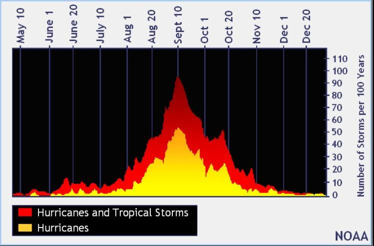
The Atlantic hurricane season runs from June 1 through Nov. 30.
Ninety-seven percent of tropical cyclone activity occurs during this time period, NOAA said.
The Atlantic basin includes the northern Atlantic Ocean, Caribbean Sea and Gulf of America, as the Gulf of Mexico is now known in the U.S. per an order from President Trump. NOAA and the National Hurricane Center are now using Gulf of America on its maps and in its advisories.
When is the peak of hurricane season?
The peak of the season is Sept. 10, with the most activity happening between mid-August and mid-October, according to the Hurricane Center.
Hurricane names for 2025 season
Here are the names for the 2025 Atlantic hurricane season, along with how to pronounce them. The first hurricane of the season typically forms Aug. 11.
National Hurricane Center map: See what forecasters watching now
Systems currently being monitored by the National Hurricane Center include:
Interactive map: Hurricanes, tropical storms that have passed near your city
Stay informed. Get weather alerts via text
What’s next?
We will update our tropical weather coverage daily.
Download your local site’s app to ensure you’re always connected to the news. And look for our special subscription offers here.
Contributor: Doyle Rice, USA Today
This story has been updated to include new information.
This article originally appeared on Fort Myers News-Press: National Hurricane Center tracking Invest 94L, Gabrielle, Humberto. Florida impacts?
Reporting by Cheryl McCloud, USA TODAY NETWORK – Florida / Fort Myers News-Press
USA TODAY Network via Reuters Connect