Most of Iowa is preparing for another round of strong thunderstorms as the National Weather Service office in Des Moines warns that more severe weather is likely across the state on Friday, April 3.
Storms swept across Iowa on April 2, with eastern Iowa under an enhanced, or Level 3 (out of 5), risk for most of the day and experiencing the system’s more intense impacts. There were several reports of tornadoes and large hail across areas of eastern Iowa, and videos of a hailstorm near Ottumwa were shared online. The National Weather Service is investigating reports, but hasn’t yet confirmed any of the tornadoes.

Here’s what to know about Friday’s weather.
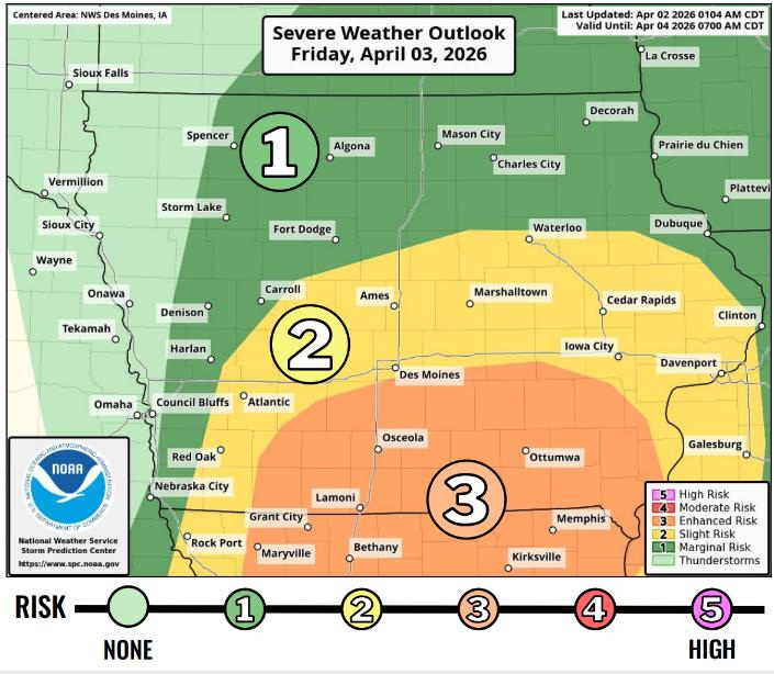
What is the severe weather outlook in Iowa for the next 24 hours?
A Slight, or Level 2 (out of 5), risk is in place for parts of central and southern Iowa on Friday, stretching from Red Oak through Des Moines and Ames and into eastern Iowa, including Iowa City and Davenport.
An Enhanced (Level 3) risk of severe weather is in place for southern Iowa, including south‑central and southeastern areas near Osceola, Lamoni and Ottumwa, where the strongest storms are expected Friday afternoon and evening.
When are severe thunderstorms possible on Friday?
The strongest storms are expected between 2 p.m. and 11 p.m. in central Iowa, with large hail and damaging winds as the main threats, according to the National Weather Service.
Storms will move quickly — around 45 mph — from southwestern Iowa into central and eastern Iowa, with hail up to 3.5 inches posing the biggest risk, wind gusts of 70–85 mph and an increasing tornado threat south of Des Moines.
Will there be tornadoes in Iowa on Friday?
Tornadoes are possible with storms that develop. Any tornadoes that do form could reach EF-2 strength, the NWS said.
Des Moines is in the 2-5% probability range for tornadoes. The highest probability range for tornadoes, 5-9%, is in southern Iowa but extends east to Iowa City and Davenport.
See the weather radar to track storms
What’s the forecast for Des Moines?
Showers and thunderstorms are likely in Des Moines on Friday, especially in the afternoon and evening, bringing breezy conditions with a high near 62 degrees, according to NWS.
Thunderstorm may linger into Friday night before gradually tapering off, with temperatures falling to around 35 degrees as winds turn northwest.
Saturday turns much cooler and breezy, with highs near 48 degrees and mostly cloudy skies, though only a 20% showers during the day. Skies will clear up Saturday night, with lows dropping to near 32 degrees.
Are there any weather warnings in Iowa?
Track the latest severe thunderstorm or tornado warnings with the map below:
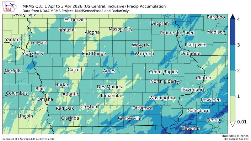
How much rain did we get? Check Iowa rainfall totals
Here are the areas that have seen the most rainfall over a 48-hour period ending at 8 a.m. Friday:
Des Moines has recorded 1.34 inches of rain, according to the Iowa Environmental Mesonet.
Get weather updates
Cooper Worth is a service/trending reporter for the Des Moines Register. Reach him at cworth@gannett.com or follow him on X @CooperAWorth.
This article originally appeared on Des Moines Register: Will storms bring more tornadoes to Iowa on Friday? Check the forecast
Reporting by Cooper Worth, Des Moines Register / Des Moines Register
USA TODAY Network via Reuters Connect