Tropical Storm Melissa is keeping forecasters guessing on where it will go and how powerful it could get.
What’s more certain is that Melissa could become a hurricane Oct. 23 and the storm is expected to bring heavy rain and flooding to portions of Hispaniola and Jamaica through the weekend.

Some areas could see up to 10 inches of rain through Saturday, Oct. 25, according to the National Hurricane Center.
➤Track Tropical Storm Melissa
➤ Weather alerts via text: Sign up to get updates about current storms and weather events by location
AccuWeather forecasters are predicting 12-18 inches, with some localized areas seeing up to 30 inches.
To become a hurricane, maximum sustained winds need to reach 74 mph.
Will a tropical storm or hurricane impact Florida? It’s possible but still unknown at this time.
“The longer Melissa tracks to the west, the greater the chance of an impact on the U.S.,” said AccuWeather Chief Meteorologist Bernie Rayno.
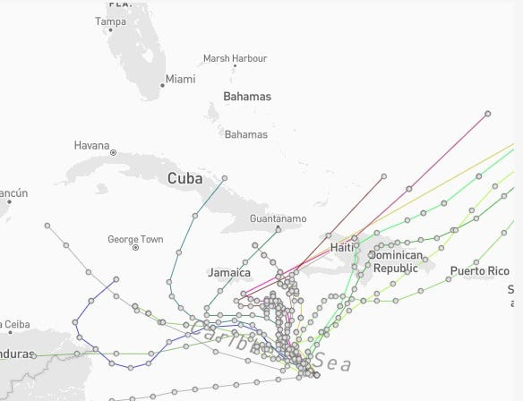
Spaghetti models for Tropical Storm Melissa. See expected path
Special note about spaghetti models: Spaghetti model illustrations include an array of forecast tools and models, and not all are created equal. The Hurricane Center uses only the top four or five highest performing models to help make its forecasts.
➤ Track Tropical Storm Melissa
Where is Tropical Storm Melissa and where is it going?
Special note on the NHC cone: The forecast track shows the most likely path of the center of the storm. It does not illustrate the full width of the storm or its impacts, and the center of the storm is likely to travel outside the cone up to 33% of the time.
Is there a hurricane coming toward Florida?
“The longer Melissa tracks to the west, the greater the chance of an impact on the U.S.,” Rayno said.
“The U.S. concern for impacts will be in the Florida Peninsula, especially the lower portion of the Peninsula and the Keys.
“Strong westerly winds, driven by the jet stream, should prevent the storm from tracking into Texas, Louisiana and the panhandles of Mississippi, Alabama and Florida next week,” according to AccuWeather.
Forecasters encourage residents to monitor the tropics and to always be prepared.
Track all active Atlantic, Pacific storms and disturbances
This auto-updated graphic shows a map of all active storms in the Atlantic basin.
Can’t see the graphic? Open in a new browser.
NWS weather radar shows storms affecting Florida
Latest weather watches and warnings issued in Florida
No watches or warnings associated with Tropical Storm Melissa are in effect for Florida or the U.S. as of Oct. 22.
Excessive rainfall forecast across Florida
Stay informed. Get weather alerts via text
What’s next?
We will update our tropical weather coverage daily.
Download your local site’s app to ensure you’re always connected to the news. And look for our special subscription offers here.
This article originally appeared on Naples Daily News: See spaghetti models, possible path for Tropical Storm Melissa. Is Florida in its path?
Reporting by Cheryl McCloud, USA TODAY NETWORK – Florida / Naples Daily News
USA TODAY Network via Reuters Connect