The National Hurricane Center is tracking a tropical wave in the eastern Caribbean Sea showing a high chance of development this week.
Designated Invest 98L, the wave is moving quickly to the west. That speed — 20 to 25 mph — should help “limitsignificant development during the next day or so,” NHC forecasters said.

➤Track Invest 98L
➤ Weather alerts via text: Sign up to get updates about current storms and weather events by location
However, by the time Invest 98L reaches the central Caribbean in the middle to later part of this week, a tropical depression is likely to form.
If it reaches tropical storm strength, with sustained winds of at least 39 mph, it would become Melissa.
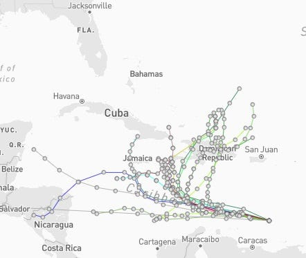
Spaghetti models for Invest 98L. See expected path
Special note about spaghetti models: Spaghetti model illustrations include an array of forecast tools and models, and not all are created equal. The Hurricane Center uses only the top four or five highest performing models to help make its forecasts.
➤ Track Invest 98L
Where is Invest 98L and where is it going?
Special note on the NHC cone: The forecast track shows the most likely path of the center of the storm. It does not illustrate the full width of the storm or its impacts, and the center of the storm is likely to travel outside the cone up to 33% of the time.
Could Florida feel impact from Invest 98L?
“As it reaches the warm waters of the Caribbean early this week, low wind shear in the southern half of the Caribbean may allow it to quickly become a tropical storm,” said AccuWeather lead hurricane expert Alex DaSilva.
Where the potential storm could go is unclear at this time since several factors could influence its path, but if a dip in the jet stream grabs it later this week, odds increase for a possible track into the Florida Peninsula. AccuWeather warned.
“The storm would have to get to Jamaica or Mexico’s Yucatán Peninsula to be of concern to Florida as we see it now,” DaSilva said. “If the system remains weak and steers westward, it may continue on a path into Central America with no additional U.S. threat.”
Forecasters encourage residents to monitor the tropics and to always be prepared.
Track all active Atlantic, Pacific storms and disturbances
This auto-updated graphic shows a map of all active storms in the Atlantic basin.
Can’t see the graphic? Open in a new browser.
NWS weather radar shows storms affecting Florida
Latest weather watches and warnings issued in Florida
Excessive rainfall forecast across Florida
Stay informed. Get weather alerts via text
What’s next?
We will update our tropical weather coverage daily.
Download your local site’s app to ensure you’re always connected to the news. And look for our special subscription offers here.
This article originally appeared on Naples Daily News: See spaghetti models, possible path for Invest 98L. Any Florida impacts?
Reporting by Cheryl McCloud, USA TODAY NETWORK – Florida / Naples Daily News
USA TODAY Network via Reuters Connect