Tropical Storm Jerry was labeled by National Hurricane Center forecasters as “disheveled” and hours later Oct. 11 was only remnants in the Atlantic.
A new tropical disturbance is in the Atlantic and could form a tropical depression next week, the National Hurricane Center’s Oct. 11 outlook stated.

Subtropical Storm Karen was downgraded Oct. 10, a day after becoming the 11th named storm of the 2025 Atlantic hurricane season. As forecast, Karen moved into colder water and became a post-tropical low.
Remants of the former Tropical Storm Jerry had 45 mph winds as it pulled away from the northern Leeward Islands and, as forecasters noted, “degenerated into a trough.”
➤ Track all active storms
➤ Weather alerts via text: Sign up to get updates about current storms and weather events by location
Jerry was not a factor in what caused all the rain along the east coast of Florida. Areas including Edgewater, Brevard County, parts of the Treasure Coast and Jupiter reported flood water on roads and in some homes and businesses from heavy rains Thursday and Friday. A section of the Palm Beaches were closed due to pounding surf and erosion.
More may be coming Saturday as conditions from a nor’easter continue, but then are expeted to pull away to the north.
Here’s the latest advisory from the National Hurricane Center as of 5 p.m. Saturday, Oct. 11:
Storm tracker: Tropical Storm Jerry dissipated
Special note on the NHC cone: The forecast track shows the most likely path of the center of the storm. It does not illustrate the full width of the storm or its impacts, and the center of the storm is likely to travel outside the cone up to 33% of the time.
Spaghetti models for Tropical Storm Jerry
Special note about spaghetti models: Illustrations include an array of forecast tools and models, and not all are created equal. The hurricane center uses only the top four or five highest performing models to help make its forecasts.
➤ Track Tropical Storm Jerry
Tropical Storm Jerry no longer expected to strengthen into hurricane
Tropical Storm Jerry became Remnants of Jerry and dissipated in the Atlantic on Oct. 11.
Special note about spaghetti models: Illustrations include an array of forecast tools and models, and not all are created equal. The hurricane center uses only the top four or five highest performing models to help make its forecasts.
Is there a hurricane coming toward Florida?
No.
On Saturday, Tropical Storm Jerry turned northward and dissipated.
What other tropical waves, disturbances are in Atlantic basin now?
Along with Tropical Storm Jerry, the National Hurricane Center is tracking four tropical waves, including two in the Caribbean:
Forecasters are watching a large area of disorganized showers and thunderstorms over the eastern tropical Atlantic several hundred miles south-southwest of the Cabo Verde Islands that is associated with a tropical wave.
“Environmental conditions appear conducive for some development of this system,” forecasters said, and this system could form a tropical depression next week while moving west-northwestward across the central tropical Atlantic.
Also:
Who is likely to be impacted by the former Tropical Storm Jerry?
Swells generated by Tropical Story Jerry are affecting the Leeward Islands, Windward Islands, Virgin Islands, Puerto Rico, Dominican Republic, and the Turks and Caicos Islands, and are likely to cause life-threatening surf and rip current conditions. These swells are expected to spread toward the Bahamas on Saturday.
What is a nor’easter? Nor’easters vs. hurricanes and tropical storms
A nor’easter is a storm along the East Coast of North America that typically blow over coastal areas. These storms can occur at any time of year but are most frequent and most intense between September and April, according to the National Weather Service.
Nor’easters usually develop between Georgia and New Jersey, within about 100 miles of the coast, and generally move northeastward,
Nor’easters are typically associated with colder seasons and form from a temperature contrast between cold Arctic air and relatively warm Atlantic waters. Tropical storms and hurricanes form over warm tropical or subtropical waters, and predominantly develop in warmer months.
Nor’easters also have a larger wind field, while tropical storms have a well-defined eye with the strongest winds near the center.
Florida weather radar for Oct. 11, 2025
Weather watches and warnings issued in Florida
When is the Atlantic hurricane season?
The Atlantic hurricane season runs from June 1 through Nov. 30.
Ninety-seven percent of tropical cyclone activity occurs during this time period, NOAA said.
The Atlantic basin includes the northern Atlantic Ocean, Caribbean Sea and Gulf of America, as the Gulf of Mexico is now known in the U.S. per an order from President Trump. NOAA and the National Hurricane Center are now using Gulf of America on its maps and in its advisories.
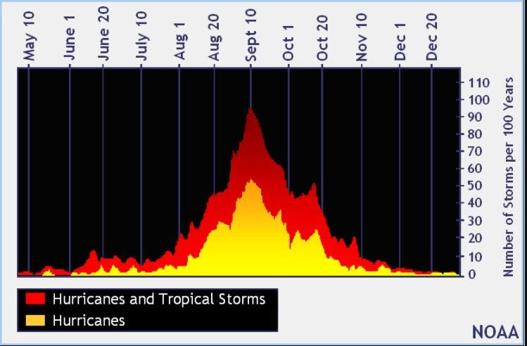
When is the peak of hurricane season?
The peak of the season is Sept. 10, with the most activity happening between mid-August and mid-October, according to the Hurricane Center.
Hurricane names for 2025 season
Here are the names for the 2025 Atlantic hurricane season, along with how to pronounce them. The first hurricane of the season typically forms Aug. 11.
National Hurricane Center map: See what forecasters are watching now
Systems currently being monitored by the National Hurricane Center include:
Why does NHC say ‘tropical cyclone’ on its maps instead of hurricane or tropical storm?
Tropical cyclone is the generic term used by the National Weather Service, NOAA and the National Hurricane Center for any tropical system, even if it’s in the tropical Atlantic basin.
To be more precise, a tropical cyclone is a “rotating, organized system of clouds and thunderstorms that originates over tropical or subtropical waters and has closed, low-level circulation,” NOAA sadi.
Once maximum sustained winds reach 74 mph, what it is called is determined by where it originated:
Interactive map: Hurricanes, tropical storms that have passed near your city
Stay informed. Get weather alerts via text
What’s next?
We will update our tropical weather coverage daily.
Download your local site’s app to ensure you’re always connected to the news. And look for our special subscription offers here.
(This story has been updated to add new information and graphics.)
This article originally appeared on Sarasota Herald-Tribune: Tropical Storm Jerry is history as National Hurricane Center tracks 4 waves
Reporting by John Gallas, Cheryl McCloud and Brandi D. Addison, USA TODAY NETWORK / Sarasota Herald-Tribune
USA TODAY Network via Reuters Connect